Pacific Crest Trail Hike: OR & WA Section K & L – Mile 2466 - 2653

Pacific Crest Trail Hike: OR & WA Section K & L – Mile 2466 - 2653
What an adventure. I was able to touch the Canadian border from the Mexican border and complete the trail in exactly 5 months. These sections are together and truncated because of fire closures that closed the majority of them. These were some of the sections I had been looking most forward to because of the infamous Washington view – specifically the North Cascades mountain range. It was a disappointment to skip even more miles, but I felt strongly about following the PCTA’s guidance. I have plans to go back to complete some of these sections in the future.
Even though I have finished what I could on the Pacific Crest Trail – thank you all for the support and I promise I am not done yet.
As a reminder: for the last few posts about the trail, things got a little chaotic, so I’ve outlined more below. The last 3 posts of the trail were split up out of mileage order so I will be posted things out of chronological order. Surprise (and not to ruin the ending for anyone) but I ended up completing the trail, which you now can see! There were a few things that worked against us relating to timing and were the reasons for our pivot out of order.
With these items in mind, Prick, Bags, and I flipped around our schedule for the remaining time on trail. Here is the outline below:
Day 145: Section L (this section)
Day 146: Section L (this section)
Day 147: Section L (this section)
Day 148: PCT Trail Days
Day 149: PCT Trail Days
Day 150: Section J
Day 151: Section J
Day 152: Section J
Day 153: Section J
Day 154: Section J
Here is Section L, aka the finish and this section, as the last blog post even though I officially finished at a different point (Steven’s Pass).
PCT OR & WA Section K & L Summary
Statistics:
Days: 3
Full hiking days: 1
Zeroes: 0
Neros: 2
Total Trail Miles Hiked: 61
Total Northbound Trail Miles Hiked: 30.5
Total Miles Hiked: 61.1
Trail Elevation Gain: 12,292 ft
Trail Elevation Loss: 12,292 ft
Highlights:
Touching the Canadian border! 🙂
The views were unparalleled.
Being with the border monument alone for 30 minutes.
Celebrating with friends that were so impactful on my hike.
Lowlights:
Touching the Canadian border 🙁
PCT OR & WA Section K & L Detailed Version
Day 145: Mile 2624.7 – 2640.6
Trail Daily Miles: 15.9
Total Daily Miles: 15.9
Total Trail Mileage: 2624.7
Elevation Gain: 3263 ft
Elevation Loss: 3212 ft
Weather: Sun, Cloud
Overall Day Sentiment: I’m touching the border tomorrow!
This picks up after Snoqualmie Pass – post found here.
The day started early as Prick, Bags, and I left our hotel before sunrise to get the rental car. We arrived at the Seattle airport received the rental car and all went smoothly. Despite concerns around Seattle morning traffic we made it through quickly. The only major hiccup was that there had been a mudslide on Highway 20 which would have been the quickest way to get to Hart’s Pass. This was our destination to start the hiking out and back process to tap the border. Because this highway was closed, it added approximately 2 extra hours of driving as we had to go across the state and up the east side rather than approaching from the west side.
But this would take us through the town of Leavenworth, Washington, which was a welcomed place to stop. Leavenworth is a small quirky town that is Bavarian themed. I had been here once before and it had many German beer gardens and food to offer. I had a resupply box waiting there for me that I had sent to myself while in Portland. So I was able to pick this up from the post office while there and have enough food for the next stretch. Prick also had sent himself his passport to Leavenworth Post office in case we needed to cross into Canada by a car to touch the border if it was closed on the United States side.
We continued on from Leavenworth (after a beverage) and our goal was Mazama, Washington. There was a hostel and a store there and this is the closest town to Hart’s Pass. When we got to Mazama, we ran into several other hikers that we had been leapfrogging with since the desert. They had just gotten back from touching the finishing monument and their excitement was palpable.
We made our way up to Hart Pass Campground, which was up a much twistier and windy road than anticipated. We talked to a Ranger upon arrival and confirmed that our rental car was okay to be parked there for two nights while we hiked in and then hiked back out. I also was able to see the logbook of everyone who had come through this spot and again got to see some familiar names. It was a small celebration of everyone finally hitting the border.
Our plan was to hike in about 16 miles, which would set us up for a slackpack to the border. A slackpack is when you have hike with less items in your pack. By hiking in 16 miles, we could slack back the near 30 miles the following day (15 miles to the border and 15 miles back) because our sleeping items would remain set up. Therefore we would not have had to bring our tents and sleeping gear – which lightens the load significantly. This was intentional because I had packed out champagne for a border celebration.
It was unfortunately 4 o’clock by the time we got to the parking lot and so the thought of 16 miles was a little daunting, but we were committed to the cause. This section of trail would go down as one of the most beautiful sections. The views from the ridge lines were incomprehensible and made me really miss the section that we had to skip due to closures.
The night came quickly as much of this hiking was in forested areas. I had gotten ahead of Prick and Bags and wanted to set up camp ASAP. My last 3 miles were in total darkness in the forest and it was probably the most scared I had been (without passes or river crossings being involved). I clacked my trekking poles together and was loudly talking to myself to alert any bears that may be in the area. My heart rate for this last hour was substantially higher than any other portion of the day. I am not too big to admit that I cried a lot in this last hour because I just wanted to be to camp.
Eventually I got there to discover that all the actual tent pads had been taken by approximately 15 other hikers. I made the best of a tilted field spot and saved some areas for Prick and Bags as well. I ate my dinner in the pitch black while waiting for them. They arrived and we made a plan for the next day – border day.
Day 146: Mile 2640.7 – 2655.2 – 2640.7
Trail Daily Miles: 29.2
Total Daily Miles: 29.3
Total Trail Mileage: All of it?
Elevation Gain: 5817 ft
Elevation Loss: 5817 ft
Weather: Sun
Overall Day Sentiment: I DID IT!
I woke up with butterflies in my stomach because I was going to touch the Canadian border – TODAY. It was a relief to leave the tent and sleeping implements set up as that cut down on my getting ready time and would save me time on the back half of the day, because everything was already set up! I packed the tiny bottles of champagne and snacks for the day and set off. It was just under 15 miles to the border, but packed a wallop of elevation gain. It was ‘uphill both ways’ as they say.
The morning was misty, but the sun peeked through and broke up the mist to deliver the views of a lifetime. This whole 15 miles is a blur because I was riding high chugging my way along to the border. The plan was to have lunch at the monument, so I didn’t stop to rest…at all? Other than slowing to get water, we all were constantly moving.
One of the biggest treats of the day was seeing hikers head southbound because they had already touched the border. It was a slurry of ‘Congratulations’ and ‘It is worth it to get there’ on both sides.
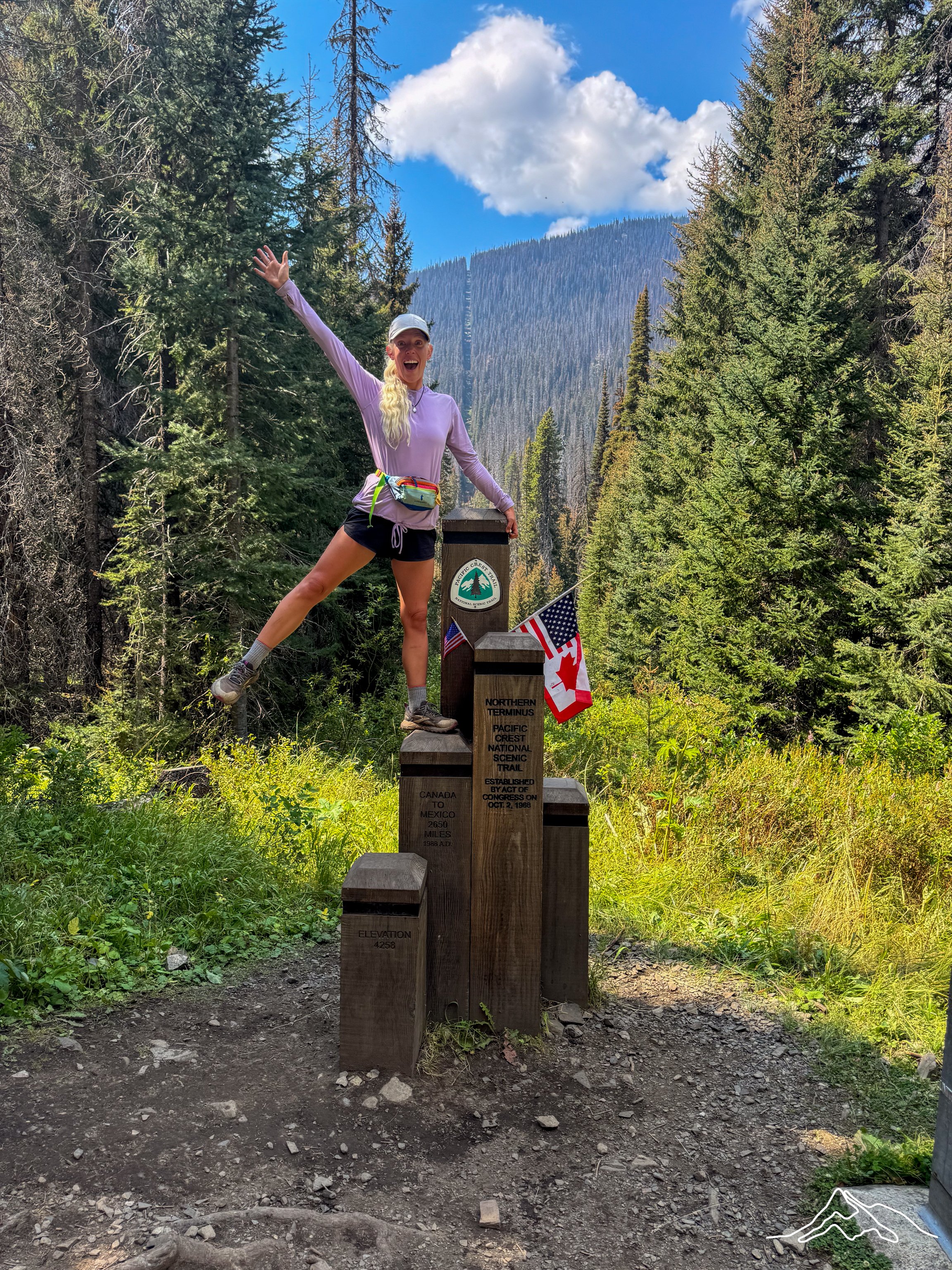
I arrived at the border by myself as Prick and Bags were a bit behind me. In a surprise Washington weather day, it was completely sunny and clear skies by the time I got there.
I was gifted with 30 minutes alone with the monument. As someone who hoped and dreamed for this hike for literal years, it was overwhelming. I had an ugly, ugly cry for some time thinking about what the last 5 months of my life had looked like. There had been so many barriers for this hike getting off the ground before it even started. Then along the way there had been even more barriers that popped up. The sheer fact that I was standing at the Canadian border while having traveled from the Mexican border on foot was (and is?) still unfathomable to me.
Bags and Prick arrived and we had a proper celebration. The bottles of champagne were popped, sprayed, and drank. The official logbook was signed. Photos were taken. Lunch was eaten. Tears (still primarily by me) were shed. Pure joy radiated from the moment.
I begrudgingly left the monument and headed south, bound for our already set up campsite. Talk about an adrenaline rush to come down from! The rest of the day provided great views – with a different perspective than before. It felt like a different 15 miles than I had already hiked because of this new direction. When I ran into hikers heading north, while I was heading south, I got to be the one to say Congratulations and other celebratory statements.
I arrived back at camp just after sunset after being gifted clear skies for sunset on the high ridges. As I settled into dinner and my bedtime routine – with my remaining tiny bottle of champagne – I felt fulfilled.
Day 147: Mile 2640.2 – 2624.7
Trail Daily Miles: 15.9
Total Daily Miles: 15.9
Total Trail Mileage: All of it?
Elevation Gain: 3212 ft
Elevation Loss: 3263 ft
Weather: Sun, Clouds
Overall Day Sentiment: Back to Oregon
Within the theme of the last few weeks on the trail, this day was also jam packed. We had the 16 miles back to the parked rental car with an 8 hour drive ahead of us to get to Cascade Locks, Oregon for PCT Trail Days.
This 16 miles also went by in a blur. This morning had relatively dense fog that obfuscated some of the views that I had seen 2 days prior. There was one amazing cloud formation that floated over a saddle between two peaks that was reminiscent of a table cloth. This reminded me of my time in Cape Town, South Africa as these clouds would always form over the iconic Table Mountain. This time, the trail lead directly through the cloud which was a fun and new experience.
Similar to the day before, I ran into some trail friends heading north while I was heading south (hi Juice, Bard, and ReRoute!) and I was so excited for them to finish their journey as well! I also encountered my first ranger asking to see my PCT permit! Hiking border to border and this was the first time! I carried it in my fanny pack the whole way so if anything, I was proud to show it off.
The miles came fast and the day flew by as I also did not stop hiking to eat, but rather we had to get to our destination. Once I arrived at the rental car, I waited for my compatriots, which is where this post picks up.
Reflection
I will be sharing more thoughts and reflections about the Pacific Crest Trail coming up here in the next few weeks/months. In the logbook at the border monument, I wrote my name and a quote that summarizes my time:
“The best and most transformative adventure that I could have ever been on!”
Several months later and I still believe that to my core.
Thank you all for the support and I promise I am not done yet.
xoxo Kanga/Leeann