North Country Trail: Pictured Rocks National Lakeshore
North Country Trail: Pictured Rocks National Lakeshore
After completing the Pacific Crest Trail, I had the confidence (audacity/boldness) to tackle the entirety of Pictured Rocks National Lakeshore solo! This is a ~42 mile segment that runs from near Grand Marais, Michigan to Munising, Michigan along the gorgeous Lake Superior. Because I was by myself (one car) and still in relatively good hiking shape, I decided to do a boomerang hike of it aka ~84 miles. This hike had been on my list for some time, but the timing never seemed to work out. Because it is a National Lakeshore, no dogs are allowed on the hiking trails which limited me even further with my pup Roo.
I had been visiting Ontario, Canada for 2 weeks leading up to this trip and since I was driving through the Upper Peninsula of Michigan back to the Lower Peninsula anyway, it felt like the right time. I was gifted immaculate weather for the duration of this hike, which I could not be more thankful for. The foliage was also beginning to change which provided peeps of colors along the way.
To prepare myself for beginning the trail in the morning, I stayed in Grand Marais, Michigan at the Woodland Park Campground. I got a basic rustic site and it was the perfect jumping off point. While I was eating dinner in the outdoor Pavillon (that had electrical outlets), I was joined by two older women. Because of my gear and a few other things, they pegged me as a thru-hiker. They were nearly triple crowners themselves! They had been piecing together different segments of the 3 major trails and over the last 15 years, they were nearly complete. We shared trail stories and it was truly a delight.
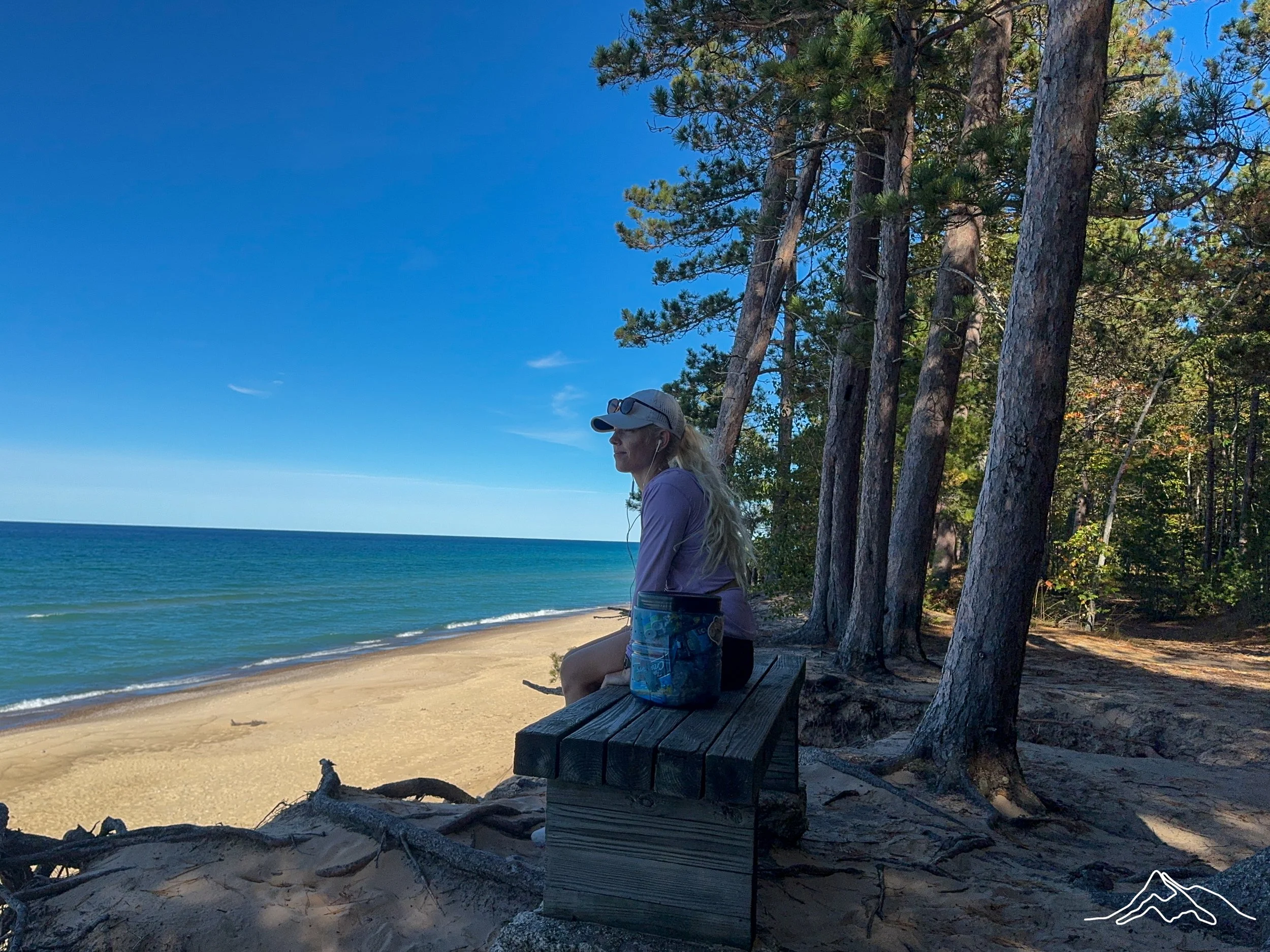
This campground is located directly on the beach of Lake Superior. I took a walk down there at sunset and though I was battered by strong Wongs - it was beautiful. As I tucked into my tent, my home for so many months, I discovered that the wind could blast sand into my sacred space. I ended up tying my tent footprint in a way that blocked the one side from the wind in between the rain fly and tent. It kept the sand to a minimum, but still.
For campsite planning purposes:
Night 1: Woodland Park Campground
Night 2: Beaver Creek
Night 3: Cliffs
Night 4: Benchmark
*Note: I took a bear can and bear spray. There are bear warning signs posted everywhere so I wanted to take extra precaution. I didn’t end up seeing a bear, but glad I brought the gear.
*Another note: As a solo woman, I felt completely safe the entirety of this trip. Everyone I interacted with was kind and presented no safety concerns.
North Country Trail: Pictured Rocks National Lakeshore Summary
Statistics:
Days: 4
Full hiking days: 3
Zeroes: 0
Neros: 1
Total Miles Hiked: 86.3
Trail Elevation Gain: 5095 ft
Trail Elevation Loss: 4956 ft
Highlights:
Completing one of the most beautiful sections of the North Country Trail in my home state of Michigan.
The weather could not have been better - absolutely perfect!
Meeting wonderful people along the way and sharing evenings around group campfires.
Lowlights:
Being tired, sore, and having a small injury on my left foot. - aka I lost PCT endurance quicker than I realized.
Ample alone/quiet time after an ideal trip for the 2 weeks leading up to this hike that ended in a confusing and disappointing fashion. This lead to a lot of conflicting thoughts and emotions while on trail.
North Country Trail: Pictured Rocks National Lakeshore Detailed Version
Day 1:
Total Daily Miles: 21.1
Elevation Gain: 919 ft
Elevation Loss: 993 ft
Weather: Sun
Overall Day Sentiment: Thankful for the outdoor community
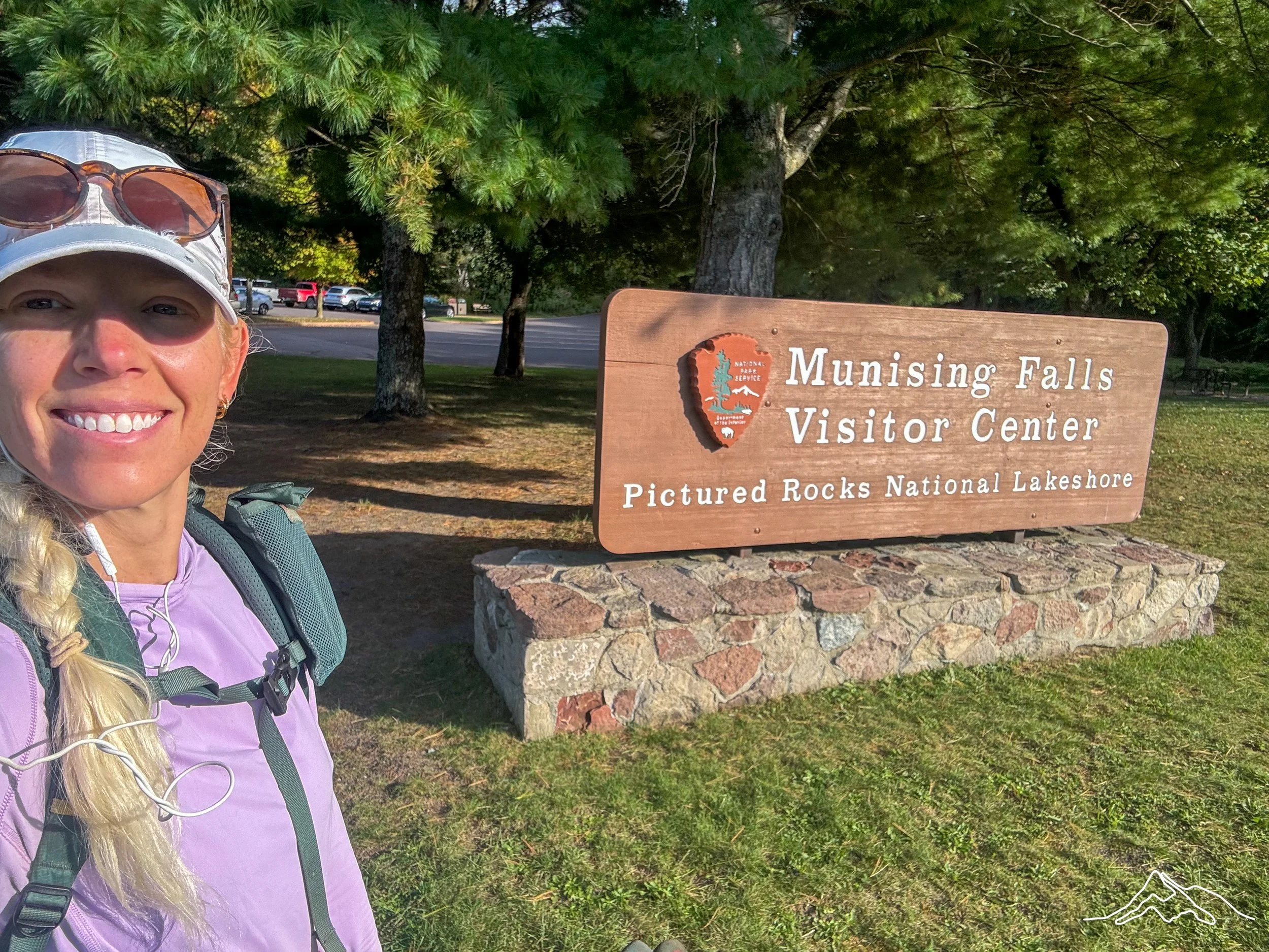
As mentioned above, I had camped at Woodland Park Campground in Grand Marais, Michigan which was a perfect jumping off point to start the trail. I got a slow start to the morning as I needed to assess the sand blasting damage of all my gear. Nothing was actually damaged, it just took some time to clean it properly. As I was heading to the Grand Sable Visitor Center, I detoured for a quick delicious breakfast at Archie’s West Bay Diner. This cozy diner was exactly what I hoped it would be; good food, substantial portions, and delightful staff. My waitress had actually be a volunteer with the parks service and was able to give me some key insights into things I should see and other tips.
After breakfast, I went to the Grand Sable Visitors Center and though it was small, it had everything you would expect. The rangers confirmed that I was allowed to park in the lot for the 3 nights I had planned and gave me ample resources. I ended up buying the annual national parks pass for $80 because I have high hopes I will make it to several more in the subsequent 12 months. It took some time to sort out my things, fill up water, lock up the car, check for my keys at least 6 times, walk back to my car to ensure I locked it, and check for my keys one more time. Then I was off!
My goal for the day was about 20 miles down the trail to Beaver Creek backpacking sites. I perhaps took a little too long at breakfast, because I was pushing my hiking time versus sunset. I got going and there were only a few notable destinations in the first 8 miles. The Log Slide area was neat, but would definitely have been difficult to get back up the steep sand dune - proceed with caution!
I stopped to have a snack at the Au Sable Lighthouse, a gorgeous open area that popped up after emerging from thick forest. There was a parking lot near there so there were more tourists in the area. One couple stopped me to chat about my hike. They were ladies in their early 60s and amazed that I was out hiking alone. We talked about the Pacific Crest Trail at length as they had many questions. At one point, one woman got completely emotional. She kept reiterating how much she wished that she had been brave enough to tackle the outdoors alone when she was younger. She had always dreamed of doing a big hike, but never felt like it was the right moment in her life.
Word of advice: there is never a right moment. Just do it.
I continued on the rest of the day and there wasn’t too many views of the large rock faces yet. Twelvemile beach, where I had lunch, was a highlight as the beach is correctly described. This section had a large campsite and nearly all of them were full. The beach was very accessible throughout this stretch and would have been a wonderful place to car camp.
When I arrived at camp, all of the other sites were occupied with a variety of people. I set up my tent and sleeping stuff quickly. There was no fire pit in my site and I realized that no other site had a fire area either. There was a group campfire pit with many logs around for seating. So I wandered up to the fire pit, which was already being used by another group and asked if I could join them.
There ended up being a family of 6 and a young couple (along with myself) that shared the next few hours together around the fire. The family of 6 had been coming to Pictured Rocks annually and always did a different section of the trail. It was their happy place and I’m thankful that I got to share in that experience for the 2024 season. The young boys of the family enjoy collecting ‘yooperlites’ which are flourescent rocks that glow under a UV light. They brought their UV light and were showing me some that they collected - picture below.
The 3 groups had little in common - except for the outdoors - and we were able to chat for hours. It is amazing what a commonality can do!
Day 2:
Total Daily Miles: 27.0
Elevation Gain: 2118 ft
Elevation Loss: 1854 ft
Weather: Sun
Overall Day Sentiment: Proud my body is still capable for long mileage
I knew that I had a long day ahead of me so I got moving pretty early, leaving camp right around sunrise. This would be my highest mileage day of the trip and I wanted to make sure I wasn’t hiking in the dark. As I began hiking, the terrain started to change in earnest. The cliffs along the shore started to get taller, the ups and downs of the trail began to get a bit steeper. My legs turned out to be a bit more sore than I originally realized.
This hiking day had a lot of the quintessential sites that Pictured Rocks National Lakeshore is known for. Early in the day, I hiked near Spray Falls - a waterfall that flows over the cliffs into the Lake. Chapel Rock, a strange rock formation that has a formidable tree growing on it with attached roots to the mainland. I had previously done the Chapel Falls loop on a trip here in 2015 but didn’t make it as far as the rock. The Mosquito River/Falls area, that luckily did not live up to its name. Bridalveil Falls, another beautiful waterfall near the lakeshore. Miner’s Castle - a building that literally looks like a castle that has now half fallen into the lake due to a rockfall. This is one of the most car accessible areas on the whole lakeshore so be prepared for crowds.
I arrived to my campsite around 3pm and had decided to do a slackpack for the remaining 10 miles of the day. Because I was planning to go and tap the Munising Visitor Center, I had 5 miles there and 5 miles back. So I set up my tent and sleeping gear - keeping food, water, and the essentials on me. But my pack was much lighter which meant I was able to go a bit faster and not get as fatigued. The 5 miles went by in a flash and I was absolutely delighted to reach the opposite end of the National Lakeshore. I used the facilities (running water, yay!), refilled my water, had a quick snack and turned around.
Even though I was going quickly, the dense forest muted the sunlight and gave the impression that it was darker than it was. Now, I felt the pressure to make it back before actual sunset in order to not use my headlamp. This 5 miles felt like deja vu … because I had in fact just done them! I arrived at the turn off for the Cliffs campsite at proper sunset and watched the sun go down over the water. Because my tent and sleeping set up was already ready, I had a relaxing evening of just dinner ahead.
Similar to the last campsite, this one also had a communal fire pit. There were only 2 other groups here (totaling 4 people) and they were sitting at their own sites. While I was making the fire, one of groups came over to join me and assisted with the fire. These were my favorite people I had met on this trail yet. They were 2 guys that were on their first backpacking trip! What a first trip - 42 miles!
We had a lot of laughs about their experience and their learning curve along the way. Their packs weight about 55-60lbs at the start of the trip, but now were less because of food consumption. It felt like a Q + A session with me about how to get their packs lighter. I am not an ultralight hiker, but I have been mindful about the gear I use in order to save some weight. My personal favorite unnecessary item they brought was a 6lb tarp “in case it rained”.
They were so endearing and positive about their whole experience (it had taken them 5 days to get to this point of the trail with low mileage) that we decided they could use some trail names. We settled on Kitchen and Timber. Kitchen was the primary offender of overpacking so he packed, ‘everything but the kitchen sink’. And Timber had poor balance, was over 6’4”, and had a doozy of a fall earlier in the week with his hands stuck in his pockets - emulating a tree falling in the woods.
Another camper from the other group popped over for a bit, which was such a treat too. We all stayed by the fire for longer than we should have (way past my bedtime!) but it was worth it.
*Note about the Cliffs campsite: it is a bit off trail and the turn can easily be missed. Make sure you have mapping material and on 0.1 miles on either side of the destination you are looking closely!
Day 3:
Total Daily Miles: 26.1
Elevation Gain: 1304 ft
Elevation Loss: 1488 ft
Weather: Sun, Chilly at night
Overall Day Sentiment: Rollercoaster - ups and downs
I woke up pretty sore from the long day prior and was taken back to painful mornings on the PCT. I could hear Timber and Kitchen mulling about their campsite, packing up. Because I have developed a system for my pack and all of its contents, packing up in the morning goes relatively quickly. I sorted my things and I was breaking down my tent shortly thereafter. Timber came over to my site as I was wrapping up as he wanted to feel the weight my pack. He nearly threw it up in the air with the vigor he used as he anticipated it being much heavier a la his pack. We laughed about it and he stated that was why I “was able to go so fast”. You’re not wrong!
The entirety of today would be walking on the trail back towards Grand Marais, Michigan aka trail I had already completed. This may sound boring, but it ended up being a real gift because I got to see things from a completely different angle - literally. There were views that I missed hiking the opposite way so this felt like I was experiencing everything the trail could offer by going both ways.
The first half of the day moved along quickly. I took a few minutes at Miners Castle area (running water + bathrooms!) and chatted with some other tourists there. As this was Day 3 of hiking, I am sure that I had begun to look a bit raggedy so they had questions for me. Again, everyone I chatted with could not believe that I was a) hiking the whole length b) hiking alone c) hiking alone as a woman. I enjoy showing people that their preconceived notions are incorrect about what long distance hikers can look like.
At some point I ran into a family of 5 that recognized me from Day 1 on the trail as I had previously passed them. They stopped me and asked which direction I was heading as confusion struck. They were beginner backpackers and were shocked that I had already touched the Munising side and was heading back. Again, it felt good to demonstrate what hiking could look like.
I stopped to have lunch down on a beautiful rock formation near the lake near Spray Falls. A ferry boat was giving a tour of the lakeshore and I was able to wave as the boat went by. At the Beaver Creek sites, I stopped and had another snack. I had 9 miles left to go and I had nearly nothing left. I cried for a bit because the top of my left foot was hurting so badly - most likely from overuse. Thoughts of giving up and just camping out there for the night crossed my mind, but I remembered the campsite reservation system and had little choice but to move forward.
The remaining 3 hours of hiking for the day were comprised mostly of listening to an audiobook or podcasts to take my mind off of my compromised foot. I’m thankful I kept going because the Benchmark campsites were great. Located right near the beach, the sunset was stunning over Lake Superior. There were only a few other campers there and they were already tucked into their tents. So I had a quiet evening in my tent, under trees brimming with Fall foliage. I continued listening to my audiobook while eating dinner as the temperature dropped. It was a cozy evening after another 26 miles and I passed out soon after dinner aka very early.
Day 4:
Total Daily Miles: 12.1
Elevation Gain: 754 ft
Elevation Loss: 621 ft
Weather: Sun
Overall Day Sentiment: 100 miles!
Because I had fallen asleep relatively early the night prior, I woke up with sunrise and got moving quickly. I only had about 12 miles left back to my origin point which felt manageable after the last 3 days. I packed up and got moving quickly. My foot remained sore and my body was definitely fatigued. But knowing that this was my last day and I would be in town later gave me the boost I needed to make haste. Remembering the feeling excitement for a town day came flooding back in from the PCT.
The rest of the day was, of course, familiar as I had tackled it going the opposite direction a few days prior. The scenery remained beautiful, the weather continued to be perfect, and overall - it was just a delight to be hiking. I finished my audiobook with my jaw agape (fwiw: read the Red Rising series) which was the cherry on top to my hike.
After arriving back at my car, I got a bit emotional. I ended at 86 miles total for the 3.5 days I was out on this trail segment. The day before I began this section, I had done 14 miles at a different state park - which meant I did 100 miles in 5 days - alone. I headed back into the Visitors Center, saw the same rangers from the 3 days prior, and was able to chat with them about the trail conditions.
Overall, I was thankful that I was gifted a perfect weather week, wonderful hiking conditions, and a body that was able to hike 100 miles still.
Please enjoy pictures of the beautiful North Country Trail: Pictured Rocks National Lakeshore section.
xoxo, Kanga/Leeann