Pacific Crest Trail Hike: OR & WA Section I – Mile 2297 – 2395
Pacific Crest Trail Hike: OR & WA Section I – Mile 2297 – 2395
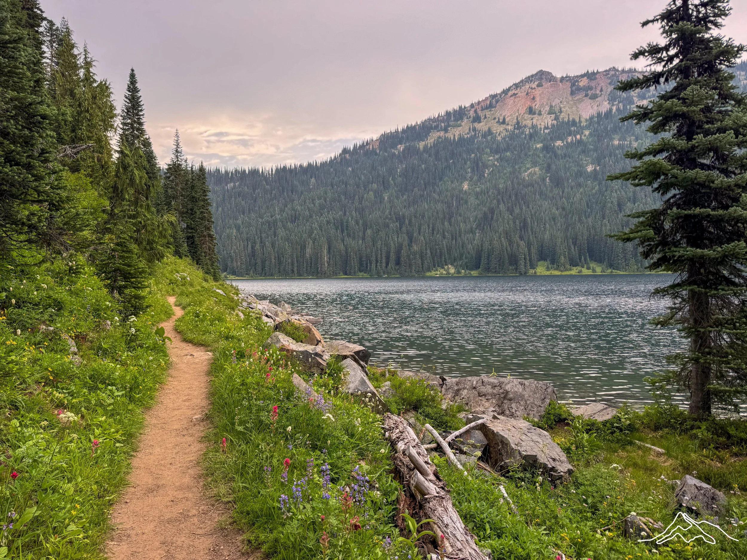
Hi! Another beautiful section and another blog post just telling you all how beautiful it was. This section was longer than I initially realized, but we slowed our hiking pace to enjoy it a bit more. This is when I really started to get the feeling of how immense Washington was and what a gift it was to hike here. Please enjoy long narratives and a lot of pictures!
PCT OR & WA Section I Summary
Statistics:
Days: 4
Full hiking days: 4
Zeroes: 0
Neros: 0
Total Trail Miles Hiked: 96
Total Miles Hiked: 96.3
Trail Elevation Gain: 17,045 ft
Trail Elevation Loss: 19,260 ft
Highlights:
Another beautiful Washington section of trail with my dear Bags and Prick.
I got to meet several new hikers and see familiar faces from literal state ago.
Crossing the 2300 mile mark!
Trail Angels, Broncé and Rosa, for all of their help!
Mount Rainier National Park and the views it provided.
The berries.
Lowlights:
Fear of new fires popping up that changed how we would continue the hike.
PCT OR & WA Section I Detailed Version
Day 141: Mile 2299.8 – 2325.4
Trail Daily Miles: 25.6
Total Daily Miles: 24.8
Total Trail Mileage: 2325.4
Elevation Gain: 4301 ft
Elevation Loss: 3825 ft
Weather: Sun, Clouds, Drizzle
Overall Day Sentiment: Thankful for new trail friends.
A trend that would start to happen in this section and continue for the remainder of the trail, is that because we were dwindling down in miles, we had to hike we would start to leave camp a later than usual. This meant that we didn’t leave camp until about 8am and moved slowly from there. Soon after leaving camp, we crossed the 2300 mile marker. Again, though I understand because of the fire skips that I wasn’t actually at 2300 miles but it still felt good to reach another hundred mile marker.
This day was beautiful hiking and overall pretty easy. There were a few river crossings, but they all had logs up or downstream that I was able to use to crossover and keep my feet dry. They were also much slower, moving rivers as compared to the raging snow melt of the Sierra.
For lunch this day we stopped near one of these beautiful rivers near the river crossing and ended up enjoying a meal with some pretty fun people. There was a German couple, Dirk and Selia, and their dog (trail name) Rudy pictured below. Rudy was similar size to Roo so it just made me miss my sweet pup at home. There was another through hiker, Raykin, who ended up being my age and we laughed a bunch as we shared a meal together.
There were also two section hikers that had recently gotten on trail from the Midwest so we bonded over the Midwest’s lack of altitude and elevation gain.They were dealing with some of the beginning problems that hikers have (ie blisters, being sore). This was also the spot that we started hearing rumors that there was a fire north of Chinook Pass, which we would run into the next day. This was called the Pyramid fire and it was small, but based on how quickly the Mine Fire grew, it had all of us concerned. The two section hikers had been heading southbound so we were able to get some information from them, which was helpful.
After lunch, there was a large climb, but it opened to beautiful views which always made it worth it. It’s sprinkled rain intermittently throughout the day, but luckily there was no downpour. This actually meant it was cooler and had great cloud formations that you could appreciate when you are on top of the ridges.
As we got close to our destination for the day, we were approaching Chinook Pass, which is a major road that goes through Mount Rainier National Park. This allows a large volume of people to come in for just the day or a quick overnight. This meant there were a ton of families, enjoying the beautiful views on the ridges and the wildflower bloom that we continue to follow.
We ended up camping at a beautiful, small pond that was ideal for both water sources, views, and proximity to Chinook Pass. While getting water for the evening and doing the evening chores (brushing teeth and washing my face), a group of women in their 50’s who were on a day hike together asked for a picture. When they were asking myself and Bags, how long we had been out and we were able to say over four months it was quite shocking to them. They went on to say how they wish they had done a big adventure like this when they were our age and that is one of their big regrets is not doing something like this.
This has been a sentiment that I have heard from women over the age of 40 or 50 consistently during (and after) this adventure. It makes me proud of what I have done thus far and makes me want to encourage women that there is much to learn from being alone in the outdoors and growth doesn’t have to stop midlife.
The sunset was gorgeous which capped off a good evening with beautiful Washington views and great friends that felt like summer camp.
Day 142: Mile 2325.4 – 2349.9
Trail Daily Miles: 24.5
Total Daily Miles: 24.8
Total Trail Mileage: 2349.9
Elevation Gain: 3506 ft
Elevation Loss: 4390 ft
Weather: Sun
Overall Day Sentiment: No Norovirus for me!
Once again, we woke up slow and got moving at an unhurried pace. With only a few miles to go to Chinook Pass, we knew that there would be some amenities (trash and a pit toilet) that we could look forward to. It’s amazing what little stuff you begin to appreciate when you have been living in the woods for several months.
Just before Chinook Pass, we ran into a group of older men who were obviously hunting. Because Bags has some experience in this realm she chatted with them for a little bit and asked them informed questions. Turns out they were hunting black bear in the area. Though I know that they’re obviously are bears in the area that I had been hiking, it is alarming to me to know that there are enough bears that there could be bear hunters. This was a great reminder that I had perhaps a false sense of security.
We got to Chinook Pass and were greeted with one of the coolest bridges I have ever seen that crosses over the highway into Mount Rainier National Park. We then followed the trail and found the main parking lot that was full of day hikers, weekend, hikers, and just general tourists heading into the park. There were pit toilets but there was not a trashcan to be found, which was disappointing.
We started up another climb to get to the famous Sheep Lake that was inundated with other hikers. There were tons of families and people enjoying the area because it was relatively accessible from the Pass. We hiked up Sourdough Gap and I had built this climb up in my mind, but with Prick and Bags company it went quickly. There was a sweet family that we all chatted with for a bit and answered their questions about a thru-hike; they even gave us cookies!
The views the top once again we’re worth it and we immediately started heading back down. There were a lot of other hiking trails in this area because we were in Mount Rainier National Park which meant I actually have to look at my map for the first time in a while because typically the Pacific Crest Trail is pretty self-explanatory.
Throughout this section, it should be no surprise that there were fantastic views of Mount Rainier itself as it is a staple of Washington. I didn’t know if there would be any clear views of Mount Rainier because of the fires in the area. The fire that we were concerned about from the day prior, ended up already being put out with a quick work from the Wildland Firefighting teams. I’m thankful to their quick action that made this small fire not become a monstrosity like a few of the other fires that I have dealt with on trail.
This section ended up having a few more dry stretches without water than we originally thought, and this was because we went through burn zones. The burn zones were short relative to some of the other burn zones that we had walked through thus far. But it’s still was on high ridges which made it exposed and there was little access to water.
Near one of the last water sources of the day were a father and son who had just started hiking this section. tThey were learning how to use the FarOut phone application, which is our mapping application software for water sources, campsites and other trail information. I did a quick tutorial of how to use this mapping software in relation to water sources because they were stuck filling up water for 30 so miles when really they only had to plan for 7 or 8 miles.
Our day ended near a cabin that is a marker on trail, but unfortunately has had a poor reputation attached to it. This cabin, the Ulrich cabin, is known for for giving hikers Norovirus. Because there is a privy toilet near the cabin, but with no water facilities hygiene remains scarce. In fact, there have been comments on FarOut attached to this cabin, that said “the CDC found Norovirus on every surface in this cabin”. So our tiny threesome swiftly walked directly past the cabin as I would not let Norovirus get me on trail.
We camped nearby to the cabin in an open field. This open field was going to provide us with a lot of condensation in the morning, but it also had a herd of elk walking through it through at sunset, which was an absolute treat. This site was also near a forest road crossing so there were some families walking in and out that chatted with us and had questions about through hiking.
Once we were all tucked into our tents, I could hear a soft snoring from Prick and Bags in their tents, but my insomnia, of course kept me up a little bit. This is when I started to hear a very strange sound of what sounded like a sermon being blared on a portable speaker . I then heard heavy footsteps in a man saying a lot of strange religious sayings that went along with this blaring sermon. He ended up walking somewhat close to all of our tents and flashed his headlamp/flashlight directly at my tent. He then said “I will be back here in the morning for them”. This was not the most comforting sound as I was trying to fall asleep therefore, my insomnia continued. But I eventually fell asleep, especially knowing Prick and Bags were near in their tents.
Day 143: Mile 2349.9 – 2375.5
Trail Daily Miles: 25.6
Total Daily Miles: 25.6
Total Trail Mileage: 2375.5
Elevation Gain: 5234 ft
Elevation Loss: 6117 ft
Weather: Sun
Overall Day Sentiment: Berry festival <3
As predicted all of our tents were in fact soaked with condensation. Packing up a wet tent is just not fun. It is also not fun when Prick and Bags did not believe my story of the 10pm walking sermon. We crossed the forest road that we had camped near and continued on again a little later than we probably should have been leaving camp.
We soon stumbled upon trail magic in a cooler at the next road crossing and at this time it was around 9am then we decided to stop and take a break already and enjoy the trail magic. Trail magic much like drinking at an airport; there’s no rules about what time of day you can enjoy an adult beverage.
This day was filled with more road crossings from small forest roads which meant that there were a decent amount of people on the trail. We ended up with a great lunch spot on a ridge with expansive views. RedRoy and Machine joined us for lunch. This was also a great spot where we all laid out our wet tents and let them dry in the sun, which helped later on in the day when we had to reset up our tents.
One of the major highlights of this afternoon was the amount of berries that we walked near and the number of different types of berries that we ate continue to grow. Huckleberries remained our primary find. We ended up having a berry gathering session later in the evening in which we had extra Ziploc bags and we filled them. This did do interesting things to my stomach so I eventually had to back off the berries a bit, but picking berries and eating them directly off of the huckleberry bush was just fun. Myself, Prick, Bags, and RedRoy had stained hands but full hearts and bellies of these berries.
We had been bouncing around another group for a few days and continue to run into them this day with Matt, Rachel, Wizard Bait. We stopped at the last water source for the day with them and got enough water for us to dry camp. There was quite a steep descent down to where we would eventually camp. Though there were many tent sites this was a popular area for people to set up for the night. We ran back into Dizzo, Squints, Lifeguard, Forest, and a bunch of other people.
I found a relatively clear spot because all of the actual tent sites have been taken. It was on a bit of a slant all night, but still remained positive. I vividly remember, listening to the end of an audiobook that had such a wild ending that I was just eating berries in my tent, audibly gasping at the twists and turns at the end.
Day 144: Mile 2375.5 – 2395.8
Trail Daily Miles: 20.3
Total Daily Miles: 20.3
Total Trail Mileage: 2395.8
Elevation Gain: 4004 ft
Elevation Loss: 4928 ft
Weather: Sun, Drizzle
Overall Day Sentiment: Thankful for helpful friends!
This was a short hiking day relative to even the shorter hiking days that we had been doing in this section. Our goal was to get to highway I-90 at Snoqualmie pass. This day had relatively easy hiking with a few big climbs a few big descent, but overall, the first 75% of the day was good. It drizzled rain here and there, but what did I expect from hiking in the Pacific Northwest?
About 8 miles from the highway crossing we stopped to have a lunch at a beautiful lake because we were ahead of schedule as my friends Broncé and Rosa were meeting us to give us a ride at a predetermined time. I ended up taking a 20 minute dirt nap as we lovingly call it at lunch as seen from a picture below. Because I was still fighting my on and off insomnia, anytime I stopped moving during the day, I typically fell asleep in and out for a bit.
The last 8 miles of the day ended up taking much longer than we originally anticipated because the terrain ended up getting hard. It was steep sections, rocky, and parts and overall just much slower because of the unsure footing.
I had visited Snoqualmie Pass in 2021 when I had done a Pacific Northwest road trip from Denver. I took a picture with the sign in May 2021 in hopes that I would someday cross this part all the way from Mexico. There is a before and after photo down below for your viewing pleasure.
My friends, Broncé and Rosa who live near Seattle were meeting us at Snoqualmie Pass to drive us into a Seattle suburb, Issaquah. This is when the logistics start to get a bit off kilter so I will eventually layout our exact path with dates. Broncé and Rosa met us at the trailhead and were patient because we were a little bit later than we originally thought due to the terrain.
They lovingly took in three terrible smelling hikers in their car and drove us out to dinner. They also had accepted our resupply packages for the next section because Snoqualmie Pass does not have great resupply options. Though the large/gas station says they accept packages, some of the comments from other hikers say that packages are either in the open are, get lost, or you have to pay upwards of $15 to pick up a package. So I’m thankful for Broncé and Rosa not only for giving us a ride in our logistical era of this trail but also accepting packages from random people and safely delivering them to us.
We went to a delicious Mexican restaurant where we all celebrated the end of another section with margaritas and we regaled our non-trail friends with stories from the trail. Broncé and I have gone to grad school together in 2020-2021 and had done a lot of group projects together. This type of bond is forever because once you find someone that actually does good group work – they are stuck with you for life.
Eventually, they dropped us off at a hotel in Issaquah that would set us up to go grab a rental car in the morning. Our group would be switching up how we finished the trail due to the fire situation in Northern Washington. But on this night, we were able to do our regular chores; shower, figure out a resupply, and thankfully do laundry. Though the soap situation at the motel left much to be desired, it was still better than no shower at all.
Enjoy photos from this beautiful section!
xoxo Kanga/Leeann