Pacific Crest Trail Hike: CA Section I – Mile 942 – 1018
Pacific Crest Trail Hike: CA Section I – Mile 942 – 1018
Hello from far down the trail! I am now deep into the Northern California section and have been hiking bigger days, therefore have not had as much time to write in the evenings.
This section was short, but not particularly sweet. It was overall frustrating and scary at times. At this point in the Sierra Nevada, I was feeling over the challenges and was ready for something new.
PCT CA Section I Summary
Statistics:
Days: 4
Full hiking days: 3
Zeroes: 0
Neros: 1
Total Trail Miles Hiked: 68.7
Total Miles Hiked: 71.1
Trail Elevation Gain: 14,063 ft
Trail Elevation Loss: 12,238 ft
Highlights:
Getting closer to the end of the Sierra Nevada Mountains.
The solid trust and community formed with hikers not only in my immediate group but also those around us.
Kennedy Meadows North was full of wonderful hikers and it was a treat to spend time with them.
Lowlights:
The water crossings were just plain scary and dangerous during peak snow melt.
The temperatures were not getting as cold overnight which meant dealing with slushier snow earlier in the day than previously experienced.
PCT CA Section I Detailed Version
Day 75: Mile 949.6 – 968.4
Trail Daily Miles: 18.8
Total Daily Miles: 19.0
Total Trail Mileage: 968.4
Elevation Gain: 4316 ft
Elevation Loss: 2746 ft
Weather: Sun, Hot
Overall Day Sentiment: Proud for doing another pass!
The climb out the Glen Aulin campsite was snow free, which felt like a real treat. The first 5 miles of the day flew by because of this. Unfortunately that luck was short lived and we ran into not just snow, but meadows that were in fact swamps. Water up to middle of my calves was the norm for the day, which was a different experience than the snow but equally frustrating. I was expecting my shoes to be sucked off by some of the mud.
We got to the end of the day, just before Benson Pass, and were feeling good so we decided to go for it! Normally I would wait until the morning for the snow to harden, but temperatures were rising steadily and it was no longer a good strategy. Getting up and over the pass put us at a great position for the following day.
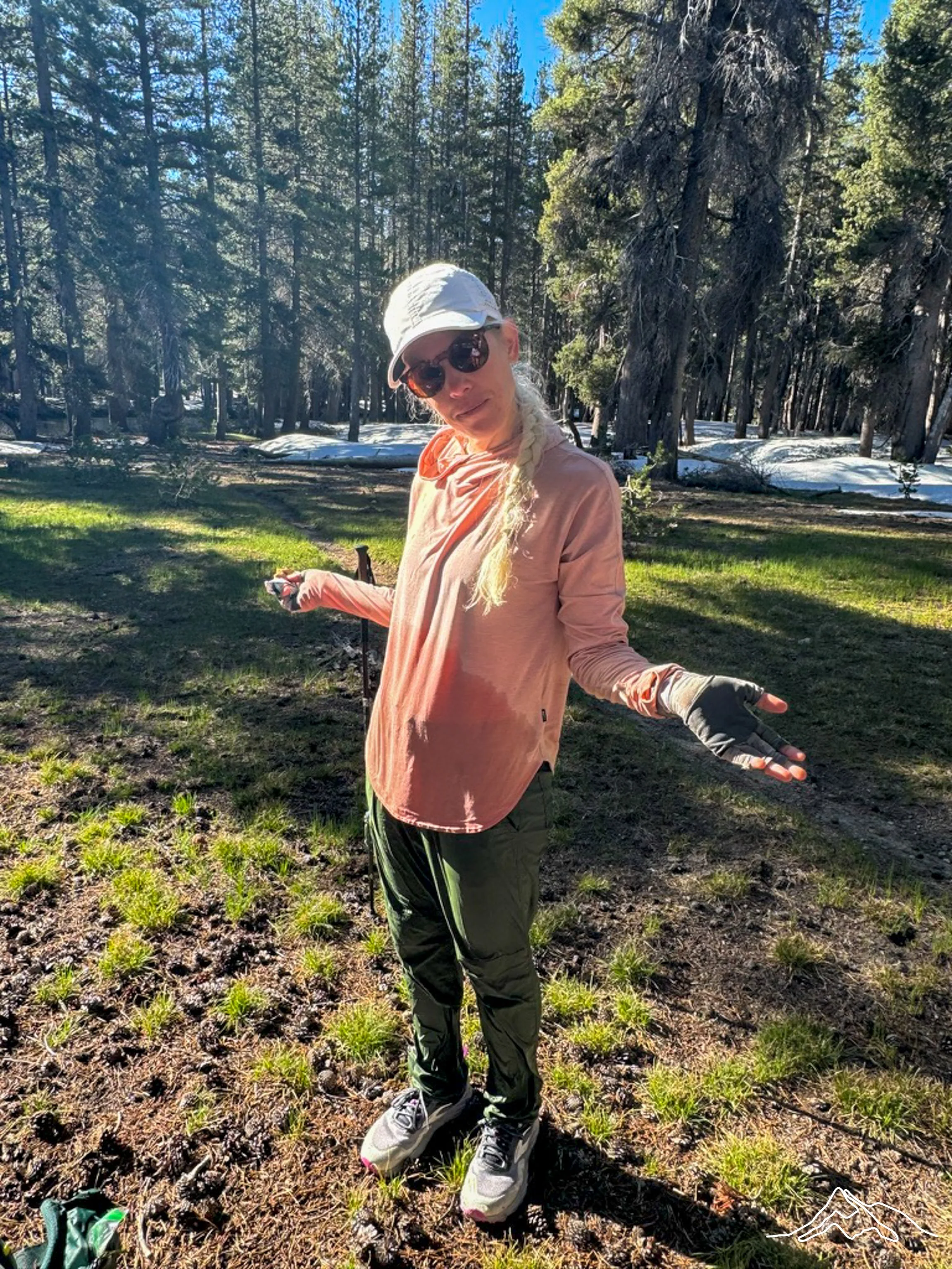
Benson Pass was easy, albeit hot. At this point in the season, the sun was beginning to get more intense, which was only amplified by walking on snow. In some of the photos below, you can see how red/pink/wind/sunburnt my face is and there was not amount of sunscreen that could help.
When we found camp on a rocky outcropping embedded within the snow, we were relieved to see that there was a small stream and waterfall that we were able to rinse off both ourselves and clothes. There was a beautiful flat rock overlooking snow capped peaks, pines, and rocks (Pictured with my sit pad below). The campsites themselves left little to be desired though and I ended up not being able to stake down my tent as there were just giant slabs of granite to set up on. I used a few rocks but mostly was thankful that I have a semi freestanding tent rather than a tension trekking pole tent.
Day 76: Mile 968.4 – 983.6
Trail Daily Miles: 15.2
Total Daily Miles: 16.8
Total Trail Mileage: 983.6
Elevation Gain: 3107 ft
Elevation Loss: 4836 ft
Weather: Sun
Overall Day Sentiment: No more water crossings please.
The morning started off with hard, steep snowy climbs. This made me grateful that we had stopped where we had the night before because doing these snow traverses in afternoon baked snow would have been more of a headache. Even with our early start time, we all ran into some snow traverses that made me just plain nervous.
There was a several mile section that walked along a creek (read: raging river at this point in the season). Unfortunately it was on the north side of the mountain, therefore south side of the creek and it was a hairy time. There was enough snow to make them full snow traverses that were collapsing but no actual trail to follow while a slide would have sent you for a swim in the *creek. These few miles were some of our slowest of the entire trail thus far.
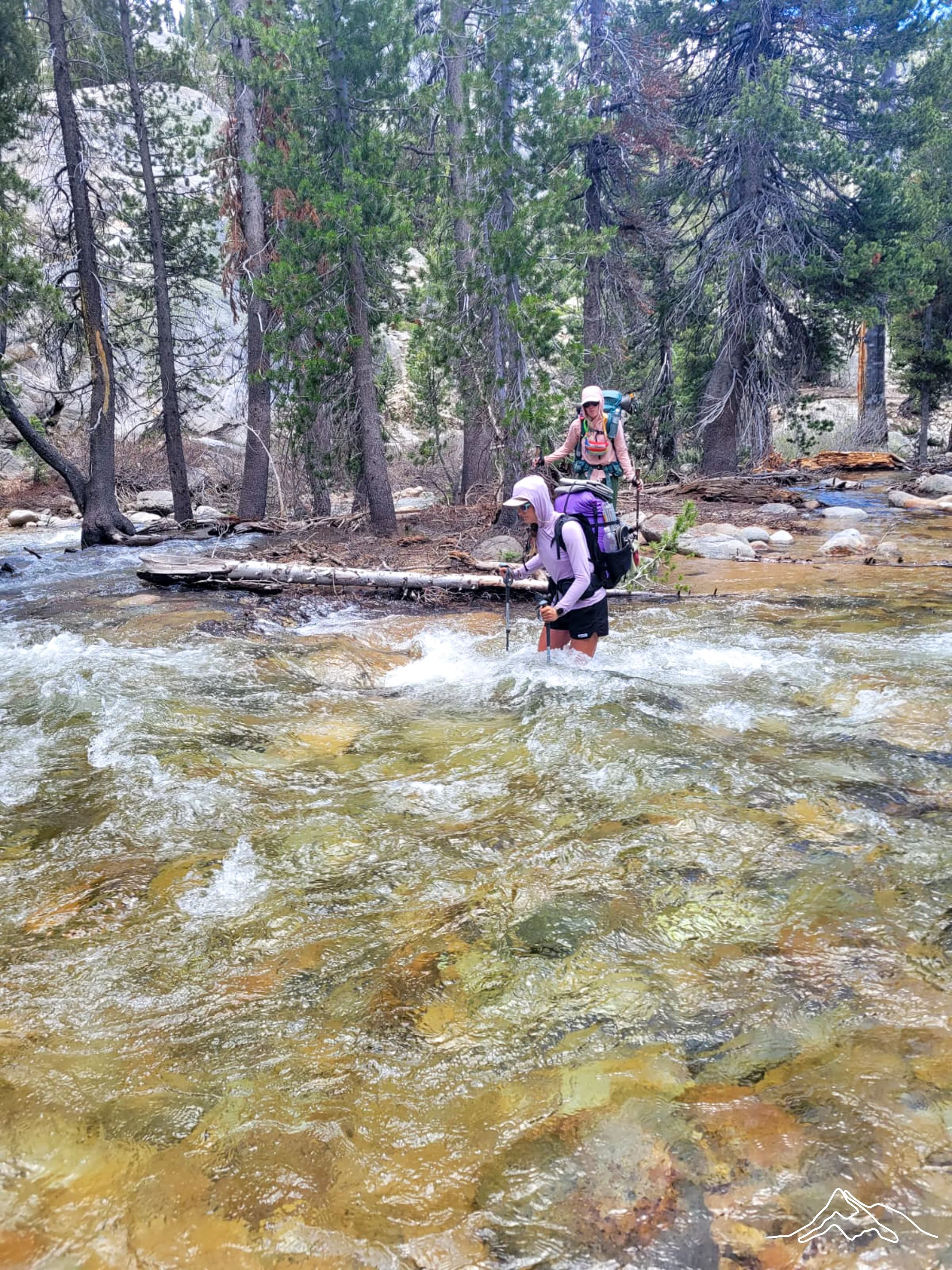
This day continued to be a challenge and was probably the worst day of river crossings on trail. There was quite a trifecta of Piute, Kerrick, and Stubblefield creek. Piute and Kerrick were strong, fast moving. It took some time to find the safest spot to cross as the actual trail is not always the right place. We often looked for branches of rivers that would cut the width and time of each section. Piute and Kerrick had those and after some holding of our breaths we got it.
Our last hurdle for the day was the Stubblefield Canyon creek which was described as wide and deep – I can confirm these were correct descriptors. As we hit it in the evening, the water levels were at their highest. There was several fast moving branches that we made it through – though Prick had to come back out partially to stabilize me as I finished crossing.
The last branch was the wide and deep part. After searching for some time and consulting with other groups of hikers, it was determined we had to swim it. I inflated my sleeping pad as Bags and Prick ferried our packs to the other side. As I was the shortest one in the group, I could not safely touch the bottom of the river and could not do much to assist.
After the cold literal swim across, we decided it best to camp for the night and not go further as originally planned. I immediately changed out of my cold wet clothing and began to make a small fire for us to warm up at. Never did I think I would need to swim in the mountains to get through the trail!
I heard rumors from other hikers that there was a log that was partially accessible and it got you across the deep wide section. This log was completely submerged at the time of day we crossed. Time of day really makes a difference in relation to creek levels!
Day 77: Mile 983.6 – 1004.8
Trail Daily Miles: 21.2
Total Daily Miles: 22.2
Total Trail Mileage: 1004.8
Elevation Gain: 3481 ft
Elevation Loss: 2635 ft
Weather: Sun
Overall Day Sentiment: Ready to be done with the Sierra.
Similar the day prior, this day was riddled with lingering snow, some snow traverses, a bit of dry trail, and a lot of water. After the day before, I was dreading more river crossings.
We made it a beautiful lake (Wilma) just around sunrise and was greeted by a lake outlet that was completely flooded. Wading in waist deep water for several minutes trying to find a ‘grassy’ underwater bridge on a chilly morning was not my personal idea of fun. Eventually we made our way to the next creek crossing, Falls Creek, and even at 8:30am had chest deep water waiting for us. Surprisingly the actual trail was the best spot to cross. It was cold and deep but slow moving.
There was a gradual incline for the majority of the day as we headed up towards Dorothy Lake Pass. This was a mix of losing the trail under the snow and finding the trail to then realize it is an actual swamp. Dorothy Lake was beautiful and the Pass was official ending of the Yosemite Wilderness.
I was thankful that the descent from the pass was tame. There were two creek crossings I was dreading but was pleasantly surprised when there was either a rock hop or a log to cross.
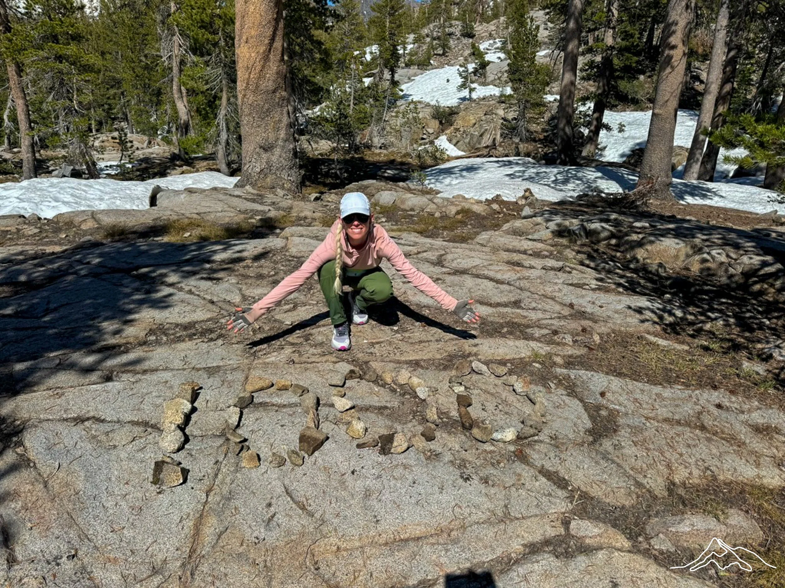
Immediately upon completing the second creek crossing, I hit the 1000 mile mark! As I could not find the 1000 mile marker, our group and another group (Curlee, Honey Bun, Big Papi, Tooth Fairy) made the sign! I’m thankful for a moment of celebration and community.
We were trying to push as far as we could to get close to Sonora Pass in the morning. There was a confusing junction and both groups ended up taking the wrong way and going a bit off trail – worst of all it was straight down and therefore straight up when we realize the error of our ways. Bags made a giant arrow out of rocks to help the next groups not make the same mistake.
After a few more miles, we tucked in for the night ready for the last significant pass!
Day 78: Mile 1004.8 – 1018.3
Trail Daily Miles: 13.5
Total Daily Miles: 13.1
Total Trail Mileage:
Elevation Gain: 3159 ft
Elevation Loss: 2021 ft
Weather: Sun
Overall Day Sentiment: Last significant pass done! Great community at KMN.
We woke up excited for a shorter hiking day and were motivated to finish up early to have more time at our destination – Kennedy Meadows North. If this sounds familiar, it is because there is a Kennedy Meadows South, which is the start of the Sierra Nevada mountains. Kennedy Meadows North is the point in the trail that all the major passes are then done and the bear can requirement is completed. More on my bear can situation in a bit..
It was snowier than we expected – typical. Luckily our sleep schedule was still shifted early so we hit the snow when it was somewhat solid. Sonora Pass is the last substantial pass in the Sierra and it was a bit more than we expected. There was a long snow traverse that required our ice axes as a precaution. As previously mentioned, we didn’t need our ice axes for either Selden or Silver pass so this was a surprise.
Once we crested the pass, there was a completely different landscape waiting on the other side. It was full of lava rocks, jagged peaks, and a complete lack of foliage. There was still snow in sections and I felt as though I took my microspikes on and off constantly. I glissaded a few times down the steep snow sections, which is much more efficient.
Upon arrival to the road crossing at the pass, we waited for a hitch. There had been an accident earlier in the day that had blocked traffic from coming through, so there was a concern that there was not going to be cars coming through. Eventually, we were picked up by a couple also heading to Kennedy Meadows North camping area and we got to ride in a truck bed! There were 5 of us in total and it was a beautiful and fun ride.
Kennedy Meadows North Resort was a nice small respite from the trail. I was able to get a bed in one of their dorms (10 beds) which is on the second floor of the main lodge. There is a restaurant and a small store there that caters to not only hikers but folks vacationing in the area as well. A (6-minute lol) shower and laundry was included which is always a treat. There ended up being several other hikers there, about 15 in total, so it was a wonderful social evening!
I ended up being the only person to not ship my bear can home because there is a small section further north named the Desolation Wilderness that requires them. It is about 24 miles long just north of South Lake Tahoe, where a friend was planning to meet me and hike a bit. It would be a big ask to have a non thru-hiker do the full 24 miles – not many can! – so I had to keep the bear can for another 150 miles. At over 2 pounds, this was unfortunate but I am a rule follower!
Enjoy some photos from this short and challenging section!
xoxo Kanga/Leeann