Pacific Crest Trail Hike: CA Section H – Mile 766 – 942
Pacific Crest Trail Hike: CA Section H – Mile 766 – 942
Hello from trail! This section is the longest on the entire Pacific Crest Trail clocking in at a staggering 176 miles! Because of this, this post is a long one with (probably) too many pictures. I grew a lot in this section partially due to the length but also the difficulty. This is the majority of the Sierra Nevada mountain range along the trail indicating that challenging… would be an understatement.
The PCT CA Section H was full of mountain passes. For those who may not know, a mountain pass is the path between two peaks that often look like a saddle or the low point. And although they are considered the low point to crest over the next ridge, they do not feel particularly low when climbing up them. This post will be littered with the word ‘pass’ and every day’s plans will be centered around how to best prepare ourselves for each of these passes.
In my mind, there are 3 categories of passes that I tackled. First, there are the 7 major high passes that the PCTA designates. Second, there are other passes on the actual trail that are considered a pass but not categorized as major. Lastly, in order to get food resupply and town access, there are *bonus passes that do not count for trail miles but do count based on how my legs felt.
This section also had a complication in the form of a major bridge – South Fork of the San Joaquin River – being down from the high snow year of 2023. The PCTA highly (read highly) encouraged everyone to get off the official trail at Bishop Pass (mm 832.2) and reenter on Piute Pass (mm 857.2) This forced us off trail for 25 miles, by trust me when I say that between the 2 passes, the miles were made up! This is also why you will see a lot of ‘???’ in relation to what trail mile I was at – sometimes I didn’t know.
I’ve listed out the passes I will be discussing in the detailed section of this post in hopes of giving context.
PCTA noted major mountain passes along the trail
Forester Pass – 13,120 ft
Glen Pass – 11,957 ft
Pinchot Pass – 12,127 ft
Mather Pass -12,094 ft
Muir Pass (I did not complete) – 11,970 ft
Selden Pass – 10,913 ft
Silver Pass – 10,778 ft
Passes along the trail that were not designated as “major”
Island Pass – 10,226 ft
Donahue Pass – 11,073 ft
Passes to get resupply or leave the trail
Kearsarge Pass – 11,791 ft
Bishop Pass – 11,972 ft
Piute Pass – 11,417 ft
Mammoth Pass – 9383 ft
PCT CA Section H Summary
Statistics:
Days: 19
Full hiking days: 9
Zeroes: 3
Neros: 7
Total Trail Miles Hiked: 202.2
Total Miles Hiked: 211.4
Trail Elevation Gain: 40,126 ft
Trail Elevation Loss: 42,986 ft
Highlights:
Being proud of myself for doing hard things.
Completing this giant section of the Sierra early in the season is an accomplishment.
Getting to know more hikers and feeling a sense of community.
Lowlights:
The Sierra Nevada mountains were difficult. Early mornings, scary climbs, fear inducing descents, added miles to resupply, frustrating slushy snow, wet feet, water crossings, and more made this not particularly fun.
PCT CA Section H Detailed Version
Day 56: Mile 772.2 – 776.0
Trail Daily Miles: 3.8
Total Daily Miles: 4.1
Total Trail Mileage: 776.0
Elevation Gain: 853 ft
Elevation Loss: 479 ft
Weather: Sun, Cold
Overall Day Sentiment: We made the right choice waiting to go over the stream crossing.
Bobcat and I woke up to see the river had in fact calmed down as compared to the evening before. While we were waiting for Prick and Bags to finish heading our way from Crabtree Meadow (Mount Whitney turnoff), we laid around and napped in our tents. As someone who had set an alarm for nearly everyday on trail, this was a refreshing morning!
Eventually we met up with the other 2 and got across the river… quite easily. The remainder of the short hiking day was in snow across snow fields and up ascents that landed us at the base of Forester Pass.
After a great dinner and some games of 20 questions, we headed to bed early due to our earliest wake up in the Sierra yet, a 3am departure time. As we were about 5 miles from the pass itself, we wanted to be at the actual approach trail by first light.
Day 57: Mile 776.0 – 791.1 (PCT)
Trail Daily Miles: 14.4
Total Daily Miles: 14.7
Total Trail Mileage: 791.1
Elevation Gain: 3232 ft
Elevation Loss: 3688 ft
Weather: Sun
Overall Day Sentiment: I completed the highest point of the PCT!
The 2am wake up call and 3am departure time came earlier than I had hoped, alas, on to our first pass! Forester Pass is officially the highest point on the Pacific Crest Trail at nearly 13,200 feet, which meant this was both exciting and nerve wracking.
The gradual incline to the approach from camp went smoothly as it was below freezing temperatures and the snow was solid. Just as we had hoped, we arrived at the approach trail that started our near vertical ascent around first light – approximately 5am.
Luckily there as boot pack zigzagging across the slope. Reminder that because I am in the Sierra early (this day was May 17th) that much of the time the switchbacks are covered with snow creating a snow wall to climb up. There were a few heart pounding moments, particularly when I had to step backwards a few steps while leading the group in the boot pack. Everyone was supportive, positive, and helpful when my nerves started to get the best of me.
Once we were up on the few exposed switchbacks, it went smoothly from there. All of us crossed the infamous avalanche chute with ease because of a really solid and deep boot pack. There was a bit of a cornice that we used our ice axes to help us up over to reach the top.
Reaching the top was emotional for me, ie I cried, because it felt like such an accomplishment to get there. It is the highest point on the PCT and one of the most talked about features of the whole trail. After years of dreaming about this adventure, it was overwhelming. I was thankful for my group who were equally as excited, perhaps not crying, but excited in everyone’s own way. I also think there has been a component of imposter syndrome because I hadn’t believed that I was a ‘thru-hiker’. But accomplishing this made me believe that I could do it.
The descent from Forester was nearly equally as hard as the ascent. Following the trail in the snow can sometimes be the wrong move because the snow covers switchbacks on the trail. Whoops! We had to do quite a rock scramble down and then controlled self arrest with our ice axes for a 200 ft steep section.
We continued down through a forested area with snow drifts that made following the trail an absolute nightmare. Attempting to look at our digital maps while staying upright on slippery snow was a task. Unfortunately this would become a trend..
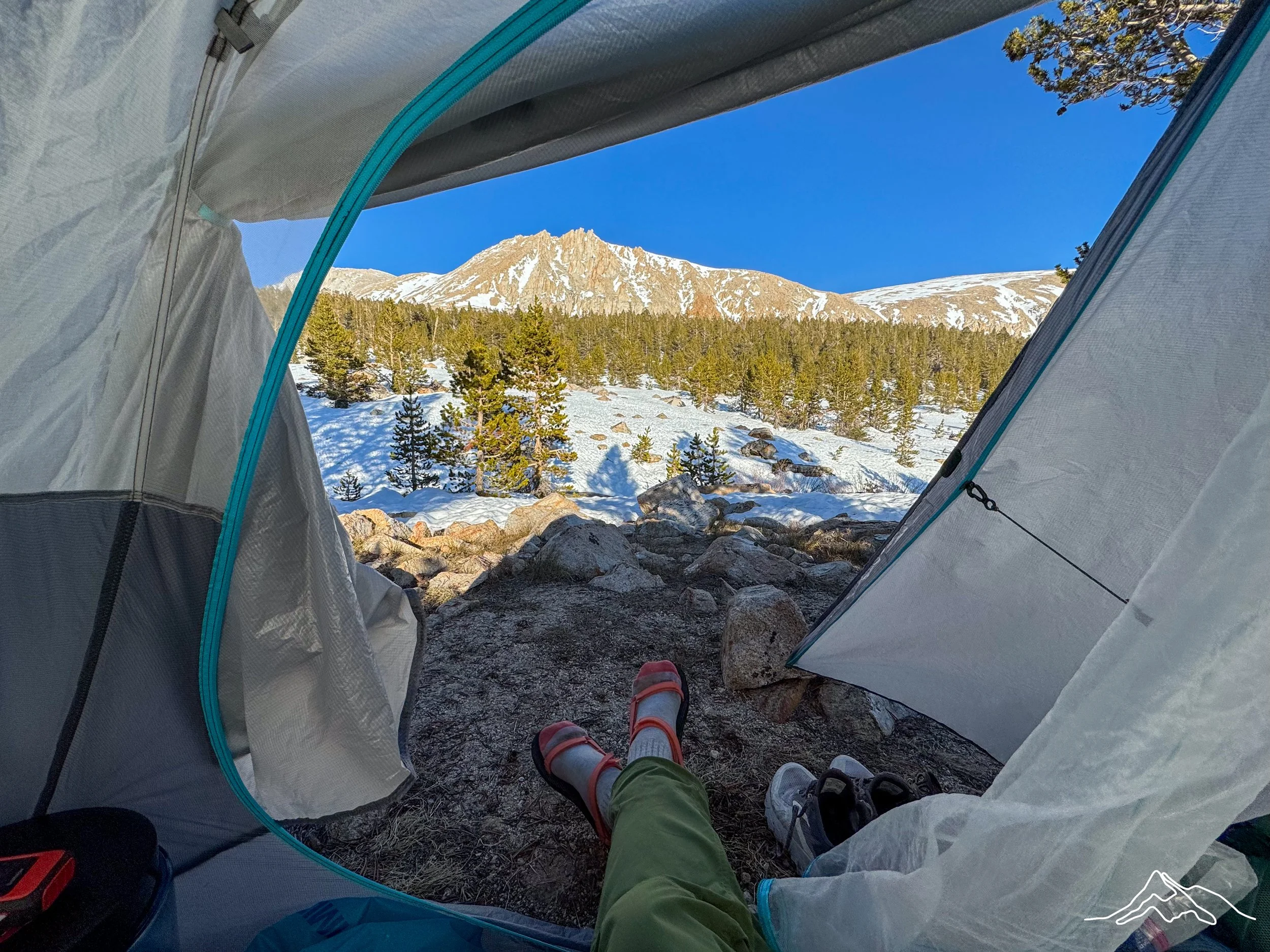
This was the first time where we got to do a *bonus pass to exit the Sierra to resupply and rest. We turned onto the Bullfrog Lake trail which would lead us to Kearsarge Pass for the following morning. Our route past Bullfrog Lake left us with no option but to camp on snow for the first time. This would also become an unfortunate trend in the Sierra Nevada. There were only a few flat-ish sites so we circled our tents (pictured below) and made the best of it. We all fell asleep mid afternoon after such a taxing day and slept through the night.
Day 58: Mile ???
Trail Daily Miles: 6.7
Total Daily Miles: 6.7
Total Trail Mileage: 790.3
Elevation Gain: 1220 ft
Elevation Loss: 2585 ft
Weather: Sun
Overall Day Sentiment: Town day and birthday!
We woke up early to tackle Kearsarge Pass. This again is a bonus pass that didn’t count for any trail miles, but was necessary for us to get more resupply. This pass ended up being quite easy with some rock scrambling that lead to exposed switchbacks – what a treat! The descent had deep and solid boot pack that felt safer than what we had experienced the day prior. There was a rock field and some accidental glissades (aka slips down hills on snow) but overall smooth.
Bobcat had arranged a ride to pick us up for the long trek to Bishop. Some folks go to the closer town of Independence but since we were doing a double zero, we wanted a slightly larger town. Eventually we got to Bishop and felt a little shell shocked from the week. I was able to grab my resupply package from the post office, then celebrations were in order!
This day was actually my 34th birthday and what a way to spend the day. I was able to celebrate a successful week in the Sierra, the highest point on the PCT, and a great group that got through together. We went to a Mexican restaurant, a brewery (second lunch!), and sushi for dinner. It was one of my best birthdays yet – though perhaps unconventional.
Day 59 & 60: Mile ???
Trail Daily Miles: 0
Total Daily Miles: 0
Total Trail Mileage: 790.3
Elevation Gain: 0
Elevation Loss: 0
Weather: Sun, Thunderstorm
Overall Day Sentiment: Happy to be in town!
My 2 zero days in Bishop were uneventful, which is exactly what I wanted. A full resupply, laundry, planning for the coming weeks, and eating nonstop were the main tasks. It was a great time to rest.
Day 61: Mile ??? – 791.1
Trail Daily Miles: 8.2
Total Daily Miles: 8.9
Total Trail Mileage: 791.1
Elevation Gain: 3169 ft
Elevation Loss: 1355 ft
Weather: Sun, Cold
Overall Day Sentiment: Where is the trail!?
We were able to get the long ride back to Onion Valley Campground trailhead early in the morning to access Kearsarge pass from a sweet trail angel Debi – thank you so much!
Kearsarge pass was as simple getting back into the mountains as getting out. A lot of snow had melted even in the 3 days since we had come out, which gave me hope for ease of hiking but also make me nervous for the inevitable high river crossings.
After we got over Kearsarge we rejoined the PCT and continued on to the base of Glen pass. The plan was to do Glen pass early in the morning before the snow got slushy, which is always the safest thing to do.
It was a frustrating slog in the afternoon snow to get to our goal destination. By the time we got there, it was very slippery and even with traction on my shoes, I continued to slip and fall. After a hard fall on a large rock that injured my elbow near camp, I was ready to be done for the day. We ended up camping on snow again and camped high – at approximately 11,200 ft. But there was not too much more elevation to go to Glen pass, which made it worth it.
Day 62: Mile 791.1 – 803.8
Trail Daily Miles: 12.7
Total Daily Miles: 14.2
Total Trail Mileage: 803.8
Elevation Gain: 2703 ft
Elevation Loss: 3858 ft
Weather: Sun
Overall Day Sentiment: A pass a day is tiring.
We abided by our early departure time of 4am in hopes of summiting Glen before the snow turned into slush. Glen pass was an interesting one as there were typically switchbacks but they, of course, were covered by snow. We headed directly up the angled snow field in convenient snow stairs that had been created by previous hikers.
I pieced together snow stairs that connected with small rock fields to break up the ascent. The best part was that there were pikas everywhere in these rock fields! If you don’t know what a pika is, please do yourself a favor and look them up.
Eventually we made it to the top and were once again greeted with stunning views on both sides of the pass. Unfortunately, we also saw the descent from the pass which was primarily an angled snow traverse with serious consequences if a fall occurred. It took over an hour to get through this initial traverse, for which we liberally used our ice axes.
Once we were mostly down, we were able to walk around the beautiful and famous Rae Lakes. The trail wove around the lakes and we had our first few patches of dry trail in awhile. Dry trail, ie no snow, indicates that I descended in elevation but this also means that I may run into things such as high river crossings or avalanche zones. Traversing through an avalanche zone is just bushwhacking and hoping for the best. Eventually we got through it and were greeted with the 800 mile marker!
There was quite a mileage stretch in between Glen pass and the forthcoming pass, Pinchot. As usual, I wanted to get as close to Pinchot pass as we could to make the morning easier and safer. After crossing frequent water crossings heading up towards Pinchot, we settled on a site about 4.5 miles out.
Day 63: Mile 803.8 – 815.7
Trail Daily Miles: 11.9
Total Daily Miles: 12.3
Total Trail Mileage: 815.7
Elevation Gain: 3435 ft
Elevation Loss: 2188 ft
Weather: Cold, Wind, Sun
Overall Day Sentiment: Another pass down!
Despite being only 4.5 miles out from the pass, it was slow going. There was one water crossing straight away in the morning which was very cold at 4:30am. The temperature continued to drop as we came closer to the pass due to the ripping winds. There was a moment where I realized I couldn’t feel my feet (ice blocks in my shoes from water crossing) nor my hands (gloves weren’t enough) so I stopped and layered up as much as possible.
Pinchot pass also had snow stairs left from previous hikers and was less steep than the prior few passes. The top was large and I found that my group had already started descending because it was so cold! Normally we celebrated on top, but with wind chills in the teens, it was too chilly to stay in one place for long.
This was luckily a much easier descent that went quickly. It lead to forested areas with a frustrating amount of snow that covered the trail. I’m thankful to Prick and Bags who are fantastic at navigating with the map through seemingly impossible terrain.
Once we were fully down from the descent, we came across the South Fork Kings River and could not find a safe crossing. After searching for a long time, we determined that it would be safer to bushwhack for 2.3 miles until the trail recrossed the river, therefore putting us on the correct side again. This river caused a PCT hiker fatality in 2017 and it was a wise decision not to cross it.
The group started the ascent during bushwhacking to Mather pass and we once again planned to get as close as possible to the base of the pass as we could. There were many snow fields to traverse once we got out of the forested area around the river. We finally called it for the day at around 3 miles away from the top of the pass because it was a slushy mess.
Our campsites were in a giant snow field bowl and was perhaps the brightest place I have ever been. After quickly setting up my tent, I dove in and *accidentally fell asleep for about a 2 hour nap. It was so bright in the afternoon though amongst the snow that I had to wear my glacier sunglasses inside my tent – and while I napped! It was also a full moon that night which was quite special in this tundra paradise.
Day 64: Mile 815.7 – ???
Trail Daily Miles: 17.7
Total Daily Miles: 18.4
Total Trail Mileage: 832.2
Elevation Gain: 2956 ft
Elevation Loss: 4409 ft
Weather: Cloudy, Snow
Overall Day Sentiment: I can sleep now that Mather pass is over.
There are some scary things in life that I go through that I wait to tell my parents about until after I am okay. Mather pass is one of those things.
Though Forester pass is the highest pass along the trail, Mather has the reputation of being the scariest and hardest. It had the steepest face of any pass and it is just generally tough.
We started our ascent in boot pack that brought us to a rock field. Our plan was to climb up this small rock field and skirt the top which would prevent us from potentially sliding in snow down… very far. Unfortunately we misjudged the angle and steepness of the rock field and ended up in a scarier situation than the snow would have been. Hiking on rocks in crampons/spikes was not easy nor fun.
After more than an hour scrambling on rocks, we opted to go back to the original boot pack in the snow and just have our ice axes at the ready in case of a fall. Once we were on the snow stairs, the pass actually went relatively smoothly. There was a small cornice at the top that was a little difficult to get over but pure excitement got me up and over. Our group celebrated for some time at the top, which was a great bonding experience.
The descent from Mather was okay – much better than Glen but a little more technical than coming down from Pinchot. I eventually got down and was greeted with walks through some gorgeous valleys. There were a few miles of open trail – what a treat! More tree blowdowns of course, but compared to snow fields, I will take the variety.
This day is where the trail split off from where the PCTA had warned hikers to get off because of the down bridge. We needed to get off at the Bishop pass trailhead to get out to Bishop and then come back in on Piute pass trail.
Bishop pass had a solid amount of ascent so we decided it would be best to tackle some of that this day rather than save all of that for the morning. After an end of day 1500ft ascent, we finally camped for the night and were just plain exhausted after the emotional rollercoaster that was Mather.
Day 65: Mile ???
Trail Daily Miles: 10.5
Total Daily Miles: 10.5
Total Trail Mileage: 832.2
Elevation Gain: 2274 ft
Elevation Loss: 2428 ft
Weather: Cold, Sun
Overall Day Sentiment: Happy to be back in town.
Thankful that we started Bishop pass the day before, we still had over 2000 ft to climb before getting to the pass. This was actually one of my favorite ascents because it was all giant stone stairs. It felt like something out of a movie or at least brought me back to the Inca Trail. Sunrise over the mountains was stunning as there were interesting clouds.
It was one of the colder passes we did though. There were of course a few river crossings which got my hiking pants wet. It was comically cold because they froze sticking straight out. I had 2 popsicles for pant legs.
Getting to the top of the pass was relatively pain free, but getting down? Wow we were not expecting what we got. There were more steep snow traverses and rock scrambles that required our ice axes. We were hopeful that the snow would have thinned out the further down we got but it was present nearly up until the end near the parking areas.
Our plan was to hitch down from Bishop pass trailhead to Bishop for a quick overnight before getting back on to Piute the next day. It was a weekend so after waiting an hour or so, we were all able to get rides! Bobcat and I got a ride with a cowboy who previously had done pack animal trips into the mountains. We enjoyed talking with him and he had a lot of knowledge to share!
Typical chores took over once we got to town; eating lots, laundry, resupply, etc. It was the Bishop Mule Days festival so town was busy and bustling – also expensive for a hotel. Thankful for a quick trip in!
Day 66: Mile ???
Trail Daily Miles: 3.2
Total Daily Miles: 3.7
Total Trail Mileage: 832.2
Elevation Gain: 1480 ft
Elevation Loss: 59 ft
Weather: Sun
Overall Day Sentiment: Short and sweet!
After a productive morning in town, we were able to get a ride back to the Piute pass trailhead (North Lake) with the trail angel Debi – she had previously given us a ride to Kearsarge!
Our plan was to do a short day to once again set us up for the pass in the morning. We found a great spot near a beautiful lake that had dry areas for our tents. It was nice to do a short hiking day and relax enjoying the outdoors. In fact, Bags and I did a quick polar plunge in the lake and then laid out in the sun to warm up. I took an afternoon nap, ate dinner, then slept well.
Day 67: Mile ??? – 863.7
Trail Daily Miles: 20.7
Total Daily Miles: 21.2
Total Trail Mileage: 863.7
Elevation Gain: 3448 ft
Elevation Loss: 3980 ft
Weather: Sun
Overall Day Sentiment: Back on the PCT!
We woke up at our early departure time again and got up and over Piute pass. This was an easy pass in comparison to others but still offered fantastic views. This was a long detour off the PCT with this pass from trailhead to PCT junction coming in at 16.9 miles. We had a lot of mileage to go so we kept on trucking.
There was not much information on the specifics of this route except for a few comments from other hikers who had done this recently. Of course there were more river crossings early in the morning. One area, French Canyon, had several sequential crossings that were easy but my goodness – cold! There were 6 crossings in a short span and I am unsure if my feet/lower legs have ever been so numb.
The trail wound its way next to a raging river along steep canyon cliffs. This was a beautiful set up, though there was more ascent than I thought necessary (or maybe just my legs did). We eventually descended back on to the PCT and popped out at mile 857. Between Bishop and Piute pass, I had actually done more miles than the 25 trail miles I missed.
We didn’t go too much further ahead for the day, but there was open trail so at least it was enjoyable! Selden pass was in the morning so I got as close as possible to that as well for snow purposes.
Day 68: Mile 863.7 – 882.3
Trail Daily Miles: 18.6
Total Daily Miles: 19.6
Total Trail Mileage: 882.3
Elevation Gain: 2969 ft
Elevation Loss: 4370 ft
Weather: Sun
Overall Day Sentiment: Another day.
Selden pass was the easiest of all the main major passes we had done so far. Though Bobcats microspike broke again so there was some time spent on a field repair. The ascent was fine, the descent was mild. Along the descent, there was a great amount of bear tracks in the snow. In fact, the bear must have also been on the PCT because it followed the trail for over a mile!
Once we were down from the descent, we ran into another large water crossing, appropriately named Bear creek. This is typically a difficult crossing but luckily we were hitting it in the morning when the snow melt had slowed overnight. There were many more minor crossings, one of which Bags quickly fell into a creek but popped right back out. She was wet but her bag liner did its job and kept her sleeping items dry!
The day flew by after that with nothing too much of note. We had another pass the next day, Silver pass, so we attempted to get as high/close as possible. The last bit of this days ascent was again on stone stairs but this time there was a consistent waterfall down it. The snow was truly beginning to melt rapidly which meant we had perpetually wet feet. I always attempt to dry out socks and shoes overnight!
Day 69: Mile 882.3 – 897.1
Trail Daily Miles: 14.8
Total Daily Miles: 15.5
Total Trail Mileage: 897.1
Elevation Gain: 4281 ft
Elevation Loss: 3317 ft
Weather: Sun
Overall Day Sentiment: Ready for Mammoth and a zero.
The 4am departure time came early again but we were about to do the last major pass (as denoted by the PCTA)! Even though we were not too far mileage wise there were several obstacles immediately apparent. There were 4 significant water crossings straight away which happened to fall before sunrise for us. One was waist deep for me being the shortest member of group at 5’5”, which was particularly cold.
The ascent continued on for what felt like forever. It was riddled with more water crossings, sun cup dancing, and postholing up to my waist. The actual vertical ascent for the pass was okay and had snow stairs for our usage. It was not steep enough to even justify using ice axes, which was a nice change of pace.
The descent was long and overall interesting because there were glimpses of trail but putting the pieces together was difficult. The remainder of the day was full of steep descents and slushy uphills. I fell and slipped down several times on this day, including a 30 foot slide into a rock. I’m thankful for some of the self arresting skills and injury preventative movements I have learned that lower the impacts of these falls.
We camped earlier than anticipated this night because it has been such an exhausting day. This was the first time that Bobcat and I had ever not met our target mileage after over 800 miles together. He also had started feeling sick this day so we were looking forward to getting to Mammoth.
Day 70: Mile 897.1 – ???
Trail Daily Miles: 10.9
Total Daily Miles: 11.2
Total Trail Mileage: ???
Elevation Gain: 1214 ft
Elevation Loss: 2231 ft
Weather: Sun
Overall Day Sentiment: 900 miles!
After a brutal day the day prior, I was thankful for a shorter day. Our goal was to take Mammoth pass out to Horseshoe Lake to catch the bus into Mammoth Lakes for a resupply and zero. Typically hikers would hike to Reds Meadow which would provide a shuttle to Mammoth – but I was too early in the season and they were still closed.
I crossed the 900 mile marker this day, which you can see picture below at just after 5am – hence the sleepy look!
Mammoth pass was fine, if only frustrating. It was much snowier than expected which meant we just kept losing the trail. It also had more ascent than what was stated on all of our GPS mapping apps so that was a bummer.
We arrived at the trailhead and much to our surprise there were about 25 other hikers there waiting for the shuttle as well! We hadn’t seen many people the past few days so this was a surprise. It was great catching up with folks I hadn’t seen for a bit and it had a great community feel. Mammoth transportation knew there were a lot of hikers so rather than use the van which would have taken hours – they brought a trolley! Thankful to the greater hiker community of Mammoth.
After a delicious breakfast, I was able to get into my hotel where I had a quiet evening to myself.
Day 71: Mile 904.5
Trail Daily Miles: 0
Total Daily Miles: 0
Total Trail Mileage: 904.5
Elevation Gain: 0
Elevation Loss: 0
Weather: Sun
Overall Day Sentiment: Happy to be on a zero.
I had a wonderful zero day in Mammoth Lakes. This town is hiker friendly, decent for walking around, and had all of the gear I needed! The day was spent as most zeroes are, doing chores. The day was topped off with a gathering of about 15 hikers for Zoo’s birthday which was a treat.
Day 72: Mile ??? – 912.2
Trail Daily Miles: 10.7
Total Daily Miles: 11.8
Total Trail Mileage: 912.2
Elevation Gain: 1371 ft
Elevation Loss: 2602 ft
Weather: Sun
Overall Day Sentiment: Happy to be around other hikers.
The plan was to leave Mammoth Lakes via Mammoth pass back from Horseshoe Lake again. The public transport was easy to manage and great! Unfortunately Bobcat was too sick to leave and needed to wait for a medical appointment, so Prick, Bags, and I headed out.
Mammoth pass was much better going this direction and we made quick work of it. After the pass and back on the PCT, we ran into some dry trail which meant we could cruise! There was another bridge out in this area so we had to cobble together some trails to see Devils Postpile National Monument and then get back to the trail. Devils Postpile is an area of basalt columns that are hexagon shaped that seemingly come out of nowhere. There are some pictures below but be sure to check out this geological feature on your own!
We ran into the same group of hikers from the party the night prior and camped with everyone at a proper campground! There were 12 of us in total and we were able to make a fire. It was a wonderful evening camping with a larger hiker community.
Day 73: Mile 912.2 – 927.1
Trail Daily Miles: 14.9
Total Daily Miles: 15.3
Total Trail Mileage: 927.1
Elevation Gain: 3356 ft
Elevation Loss: 1562 ft
Weather: Sun
Overall Day Sentiment: Snow camping again??
Bags, Prick, and I left the larger group at our earlier morning start time with the goal of making it near the bottom of Donahue pass. It was pretty easy trail for the first half of the day with little snow to speak of as we winded through the valleys.
The second half of the day was inundated with snow and therefore tons of sun cups and postholing. We arrived at the beautiful Thousand Island Lakes area which was still frozen over. The group from the night before and other groups actually all congregated for lunch which was a great social treat! The 3 of us decided to push another 3 miles to get as close to Donahue as possible. My goodness this was slushy and frustrating! More snow slipping and constant falling rounded out the day.
Day 74: Mile 927.1- 949.6
Trail Daily Miles: 22.5
Total Daily Miles: 23.3
Total Trail Mileage: 949.5
Elevation Gain: 2165 ft
Elevation Loss: 3875 ft
Weather: Sun, Wind, Clouds
Overall Day Sentiment: Proud of myself for a big day!
Our early morning departure time of 4am rolled around again and we got moving. Donahue pass is not one of the major passes but it should be given some thought. We were able to use intact snow bridges to avoid water crossings in the early morning hours which was a gift. There was strange weather coming in as we were getting to the top of the pass and the wind proved it!
Getting down from Donahue was a test for my knees and overall patience. It hadn’t been getting as cold at night as weeks prior so the snow was just a bit less solid than what we were used to. Many postholes and slides later we arrived in Yosemite wilderness.
This day had more descent than ascent but was overall gradual after Donahue. I was able to do one of the biggest mileage days because of this. There were great views in the wide open meadows but this also came with swampy/muddy conditions than had my feet wet the whole day. We walked through Tuolumne Meadows, which previously had been a staple for hikers. The campground, store, and post office was closed for the season along with the main road that would lead into Yosemite Valley. This was the reason I had such a large food carry from Mammoth Lakes.
Eventually we made it just past Tuolumne Falls and had a wonderful campsite with other hikers along the river. A great way to end the day and section!
Please enjoy these photos! It was hard to narrow it down but I hope this captures a little peek of what I am experienced.