Pacific Crest Trail Hike: OR & WA Section A & B – Mile 1692 – 1774
Pacific Crest Trail Hike: OR & WA Section A & B – Mile 1692 – 1774
Hello! This was my first full section in Oregon and I was thankful to have completed California! This is why the title has changed format a bit – the lettering of sections restarts in the new state and will continue until the end of the trail.
The first few days in Oregon were full of highs and lows. Ashland, Oregon was a wonderful trail town that offered a unique cultural experience. The days of hiking afterwards were long, but relatively easy hiking, with the wonderful addition of mosquitoes. Though the delineation between California and Oregon is relatively arbitrary, it really felt new.
PCT OR & WA Section A & B Summary
Statistics:
Days: 5
Full hiking days: 3
Zeroes: 2
Neros: 0
Total Trail Miles Hiked: 77.1
Total Miles Hiked: 72.4
Trail Elevation Gain: 11,104 ft
Trail Elevation Loss: 12,760 ft
Highlights:
First full section in Oregon offered different landscapes and views.
Ashland, Oregon was a wonderful place to double zero!
Lowlights:
Miles seemed to come slower and hiking days dragged on.
Mosquitoes were beginning to make a more imposing appearance.
My personal life began to weigh on me and I was questioning whether or not I should be on trail.
PCT OR & WA Section A & B Detailed Version
Day 112: Mile 1697.2 – 1719.9
Trail Daily Miles: 21.6
Total Daily Miles: 20.1
Total Trail Mileage: 1719.9
Elevation Gain: 2551 ft
Elevation Loss: 4985 ft
Weather: Sun, Hot
Overall Day Sentiment: Excited for Ashland!
With the excitement of crossing into Oregon from the day prior, I was even more excited to get into Ashland. Ashland, Oregon had been on my list of destinations to visit (even made the short list of places I could move to) for awhile. It was a short day with about 21 miles until the highway crossing that would take me into town. It is wild the mentality shift that I now considered a 21 mile day a “short” day and perhaps nearly a nero. I also crossed over the 1700 mile marker on the trail. Although the fire closures made it so the mile markers are no longer fully accurate in relation to the miles that I hiked, it was still exciting!
The day was full of rolling hills and overall easy terrain. As I have mentioned before, I felt like I continued to follow the flower bloom up in latitude and this was no exception. The fields of flowers were expansive and a joy to walk through. I passed several organized hiking groups that were out there to see and photograph the flora. It was a reminder of how lucky I am to be out in the wilderness everyday and see the small beauties that the outdoor environment had to offer.
Because of the fires in the past few sections, there were slated to be many hikers in town at the same time which only made me more excited to get into town! Yeti and I decided on a roadwork the last few miles as it was a bit more of a direct route. We also decided at some point that we would just call an Uber into town rather than waiting on a hitch. Because of the ongoing heatwave, I was ready for a shower and air conditioning.
That night a few hikers (Prick, Yeti, Frozen, Bigfoot) went out to dinner at a great brewery that had gluten free pizza for me – which was always nice. Later on Yeti and I met up with another group of hikers (Marg, Zoo, Tap, Juice, Giggles, Smiles, Chesky and more) and went out to a few bars. Though this was very fun at the moment – tequila shots are pretty much always a bad idea 🙂
Day 113 & 114: Mile 1719.9
Trail Daily Miles: 0
Total Daily Miles: 0
Total Trail Mileage:
Elevation Gain: 0
Elevation Loss: 0
Weather: Hot
Overall Days Sentiment: Thankful for a double zero
The night out at the bar really caught up with me and I have never been more thankful for a zero day in town. In fact, I decided that I wanted to do a double zero as I hadn’t had one since Burney Mountain Guest Ranch. So the majority of my first zero was spend lounging/napping/recovering which was a treat but also necessary. Because of this, I also decided that I would not be drinking any alcohol for the remainder of the miles in Oregon – which may give you an idea of my health for the day… It was still dreadfully hot outside so I was thankful for the climate control and good company.
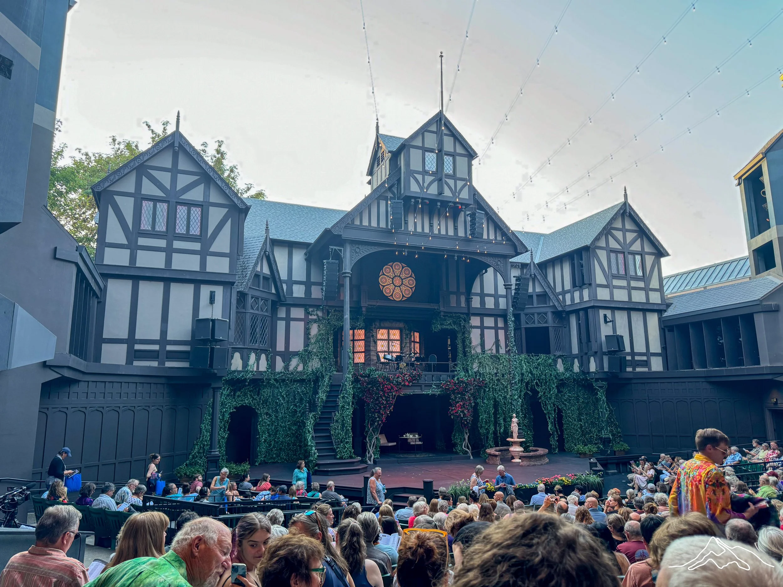
Ashland, Oregon is known for their all summer Shakespeare festival and have several shows going for weeks on end. Prick, Yeti, and I ended up at Much Ado About Nothingand it was a delight! This specific show was held outside in a beautiful theater that was a perfect homage to the Elizabethan time. I did not have seeing a Shakespearean show on my hiking the Pacific Crest Trail bingo card, but I am so happy it worked out!
My second zero in town was a bit more productive. A full resupply for the next section along with creating and sending a box to a future destination was my main goal for the day. I was able to have ample family and friend FaceTime time which filled my social self up. Staying in town and connecting with those from home does come with some downsides; feelings of missing out and not being present for big events or decisions. It was always bittersweet.
Day 115: Mile 1719.9 – 1745.9
Trail Daily Miles: 26
Total Daily Miles: 22.8
Total Trail Mileage: 1745.9
Elevation Gain: 4716 ft
Elevation Loss: 3890 ft
Weather: Hot
Overall Day Sentiment: A beautiful sunset offers perspective
It was always a task to be motivated to go back to the trail after a zero, or in this case a double zero. Eventually Yeti and I made our way back and were thankful that our driver dropped us off past the roadwork near the highway. This day of hiking was an average one of just getting in miles. The climbs were gradual, hills were rolling, and water sources scarce but manageable. There were some beautiful rock formations on the climb out of Ashland, but looking back at my camera roll, I took almost no pictures this day until camp.
This section of trail had several reservoirs or lakes that were good markers for how far I needed to go in a day. There was an established campsite near Hyatt Lake Reservoir that could also be accessed by car campers that was my destination for the evening. In fact, it was near a horse camp so there were a ton of horse trailers and horseback riders. After getting my tent set up, I swam in the lake for awhile as it was still hot outside. There were many families enjoying the campground and doing a variety of water activities. Though I enjoy being around thru-hikers, it was a refreshing reminder that the outdoors is an inclusive space. The sunset was an absolute treat which was a great way to cap off an otherwise average day.
Day 116: Mile 1749.9 – 1774.4
Trail Daily Miles: 29.5
Total Daily Miles: 29.5
Total Trail Mileage: 1774.4
Elevation Gain: 3837 ft
Elevation Loss: 3885 ft
Weather: Hot, Buggy, Thunderstorm
Overall Day Sentiment: Huckleberries are such a treat!
The day started early to beat the heat. Though it was still warm at the peak of the midday heat, it was cooler than it had been in Northern California – for which I was grateful for. As mentioned in the day prior, lakes or reservoirs were the basis of my decision making in how far I wanted to go. Yeti and I chose to attempt to get to Fish Lake, which had a restaurant and store (I am always motivated by ice cream). The first portion of the day was filled with flat sections or gradual climbs. I did not fully realize that there was going to be such a difference in the trail grade in a short span between the end of California and the start of Oregon, but it was a welcomed change!
Oregon is also known for having large sections of trail with lava rocks as it is within the Cascade Mountain Range, which is volcanic in nature. Yeti had mentioned the day prior how he was surprised we hadn’t yet run into them. I had not been looking forward to them because they are tough on your ankles, wear down your shoes faster, and absorb/retain head from the sun. Welp, we got our first dose of them on this day. The lava rock section was not too long, but it was interspersed with forested sections.
There are few cabins or shelters along the Pacific Crest Trail, in direct contrast to the Appalachian Trail, but the South Brown cabin is one of them. It has an old time water pump that is best used with two people. There was an informal trail log inside, which are always fun to look at as it gives you an idea of where other hikers you have met are in relation to you. As you go on in the trail, you begin to wonder about hikers you met in the first few hundred miles, where they might be, and more importantly hope that they are still on trail.
After the cabin is when I ran into swarms of mosquitoes. They were bad enough that I finally gave up and put my head net on, which I was thankful to have easily accessible while still walking. Unfortunately, these mosquito swarms began near where huckleberry bushes also were so it was a hard fought battle of nerves if I wanted to stop and grab berries enough to be partially eaten alive myself. I finally admitted defeat and put on bug spray on my exposed skin, though I detest wearing it. Oh well, needs must.
Because I had taken too long at the cabin, I realized that I was not going to make it Fish Lake in time to go to the resort to get my ice cream… sad. Nevertheless I hiked fast that afternoon/evening because there was also a surprise thunderstorm. Normally I would not like hiking in the rain, but it cooled everything down, tamed the mosquitoes for the moment, and did motivate me to hike faster and get to camp at a decent time.
Camp ended up being near the highway but also near a fast flowing river. Again, Oregon water sources had been hit and miss thus far so it was a treat to be near clean, cool, moving water. Everyone else had a similar idea as there were probably a dozen other hikers camped in addition to Yeti and myself. Though that sounds like a party, everyone seemed to turn into their tents early.
Enjoy photos from the first full section of Oregon!
xoxo Kanga/Leeann