
Appalachian Trail Hike: Georgia - Mile 0 - 78
Appalachian Trail Hike: Georgia - Mile 0 - 78
Hello from the trail - again! It is surreal to me that I am once again on a long distance hiking trail, but I couldn’t be more thankful.
Georgia was more challenging than I anticipated, but equally rewarding. One unique piece you will notice from this post is that there are a lot of statistics from the first 2 days that are not on other days. The Appalachian Trail officially starts at Springer Mountain but the unofficial start includes an 8 mile approach trail, which I will discuss below. This is the only time there will be such a chaotic amount of statistics.
Appalachian Trail: Georgia Summary
Statistics:
Days: 4.5
Full hiking days: 4
Zeroes: 0
Neros: 1
Total Trail Miles Hiked: 78.3
Total Miles Hiked: 87.4
Trail Elevation Gain: 19,068 ft
Trail Elevation Loss: 18,956 ft
Total Elevation Gain: 22,295 ft
Total Elevation Loss: 20,350 ft
Highlights:
Starting the Appalachian Trail. Thankful for another long distance trail so soon after the PCT.
Overall my body performing well in the circumstances.
Meeting kind people both on and off trail.
Lowlights:
The weather is already a different animal that I am perhaps not fully prepared for.
Gear not performing as well as I would like.
The hiking is just plain hard. No amount of training could have prepared me for this.
Appalachian Trail: Georgia Detailed Version
Day 0: Approach Trail Part 1
Trail Daily Miles: 0
Total Daily Miles: 1.7
Total Trail Mileage: 0
Trail Elevation Gain: 0
Trail Elevation Loss: 0
Total Elevation Gain: 1086 ft
Total Elevation Loss: 269 ft
Weather: Clouds, Rain
Overall Day Sentiment: Surreal to be here
Getting to the trailhead often presents numerous challenges as there are many logistics to get right. Despite my flight being delayed, I ended up arriving to Atlanta on time. My checked bag was the first off the plane which housed all of the items that I was not allowed to bring on carry-on such as my knife, tent stakes, trekking poles, etc. This also happened to be the same luggage that I purchased in Seattle when I flew home from the end of my PCT hike.
From there, I took the MARTA train to Sandy Springs. This is a suburb north of Atlanta that many AT shuttle drivers will pick you up at. There’s also conveniently an REI there that I was able to grab fuel for my stove before I hit the trail.
I chose Ron’s Appalachian Trail shuttle service, which was a fantastic choice. Myself and three other hikers (Cyclone, Peace, David) enjoyed the ride with Ron as he was a wealth of information. It was a great and welcoming way to start off the trail.
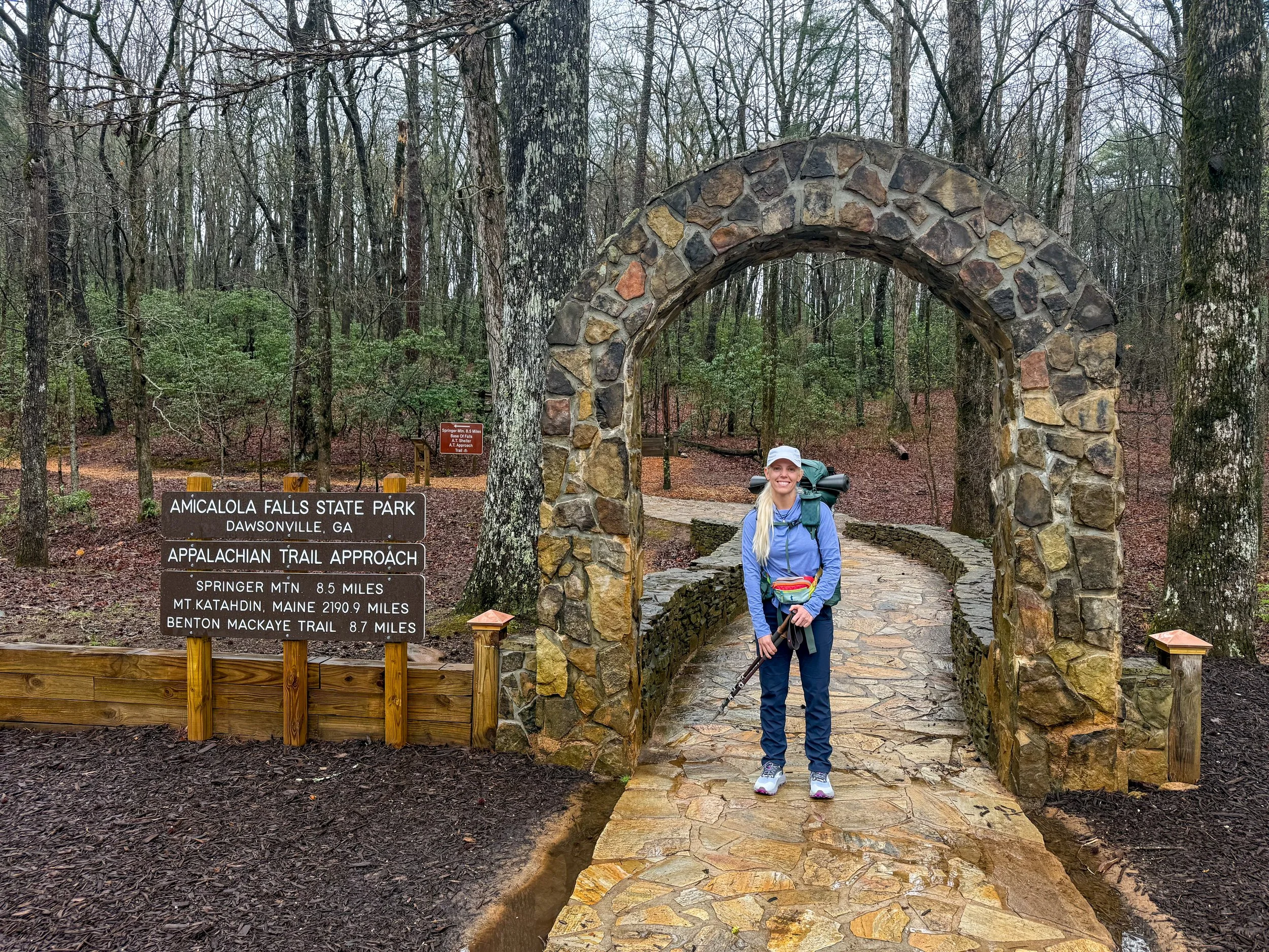
I ended up staying at Amicalola Lodge, which is just over a mile of the approach trail. There is an over 8 mile approach trail to the official start of the Appalachian Trail at Springer Mountain. This is a beautiful trail that flows through Amicalola Falls State Park and is generally considered a rite of passage.
I had a big mileage day planned for day 1 so I thought it best to start at the visitor center on my travel day and then hike up a bit of the approach to the lodge. It is not officially a part of the AT therefore it does not count against my 100 days hence why I have labeled this day as Day 0.
At the visitor center I was introduced to some lovely volunteers and Ranger that went over an introductory video to leave no trace principles and general information about the AT. Though I detest having my bear can as added weight, it does seem like the better alternative to all of the bear hang requirements for those with a bear bag.
As I went through the arch of the approach trail, it was a bit overwhelming. When I started hiking the PCT never did I think that I would do the AT. I actually always made up excuses of why it would never happen and yet here I was seven months after I finished the PCT. My hiking companion from the PCT, Prick, would constantly say that I would do the AT next year (aka 2025) and I brushed him off. Alas - he was correct… but don’t tell him. I continued and walked up all of the steps to the lodge and it was a strenuous, but absolutely gorgeous walk up along the waterfall.
Once at the lodge, I checked into my room and went to dinner by myself. It was a calm way to celebrate the start of another adventure with good food, a drink, and a beautiful view.
As my nerves were starting to set in as I was getting ready for bed, I talked to both my mom and Bobcat (that you may remember from the PCT). It was a full circle moment of support as I departed on another adventure.
Day 1: Mile 0 - 15.7 (plus Approach Part 2)
Trail Daily Miles: 15.7
Total Daily Miles: 23.1
Total Trail Mileage: 15.7
Trail Elevation Gain: 2800 ft
Trail Elevation Loss: 3796 ft
Total Elevation Gain: 4941 ft
Total Elevation Loss: 4921 ft
Weather: Sun
Overall Day Sentiment: Am I ready for this challenge?
After a decent night of sleep at the lodge, I met Cyclone, who was on my shuttle the day prior, for an early breakfast. The weather looked beautiful for the day so after getting back into my room and organizing my bag, I set out on the approach trail to head to Springer Mountain, which is the official start of the AT.
The Appalachian Trail is known for having a harder hiking than the Pacific Crest Trail. Because the PCT is graded for stock animals while the AT is meant for pedestrians only therefore can have whatever terrain or grade that it wishes. Though the approach trail is not officially a part of the AT, it abided by these rules as well. Some of the initial miles were slower than I planned for which made me a bit nervous for the high mileage day on the docket.
Once arriving to Springer, the gravity of what I was about to do (again) set in. There were several other hikers there that included hopeful thru-hikers, section hikers, and day hikers. This is the location of the first white blaze of the entire trail. The AT is well marked by having white painted blazers on trees, rocks, or other various items along the trail. To see the first one of the inevitable thousands that I will eventually see was special.
After departing Springer Mountain, the trail got easier for at least 8 miles. I ran into some volunteers who were chatting with hikers, and they were excited for all of the hikers coming through. It was encouraging to see the AT community already so close to the start of the official trail.
The next few miles were relatively flat and went to a canyon that was wet, and it looked like Washington. The day was rolling after that with only one significant climb, heading up Sassafras mountain. Just before this climb, a trail angel was waiting for us and provided treats and safety gear to get us started on the trail. Thank you, Max Forester!
My goal was to get to Gooch Mountain shelter for the night, which was about 5 miles from the trail magic. After Sassafras Mountain, it was smooth sailing from there and I arrived at the shelter just before 7:00pm. There were several people here so I got a tiny tent site and poorly set up my first pitch of my tent on the trail.
I went to the shelter, which was full of people sitting at a communal picnic table and made dinner. One of the unique components of the AT over other trails are the shelters along the way as this is natural place for people to congregate. I had dinner with kind people (George, Flatlander, Nat, TicTac, Critter, Freddy, and more!) some of who I continue to see on the trail today.
While getting ready for bed and taking off my socks, I discovered a familiar friend: blisters. They were not as bad as they were on the previous trail, but definitely something to monitor.
Day 2: Mile 15.7 - 35.5
Trail Daily Miles: 19.8
Total Daily Miles: 20.1
Total Trail Mileage: 35.5
Elevation Gain: 5027 ft
Elevation Loss: 4204 ft
Weather: Clouds, Rain, Mist
Overall Day Sentiment: Wait, I don’t want to do this.
As expected, I slept poorly from my first night on the trail. Getting back into the swing of sleeping in a tent, takes some time. There was also several people who were snoring in their tents that added to lack of sleep.
I got a slow start and began hiking around 8:30 AM. I had planned to go just over 20 miles this day so that timeframe was already pushing it based on the elevation I needed to do. The first several miles went smoothly, but then clouds and mist rolled in making everything damp and creating on and off rain.
There were a number of large climbs for the day the biggest of which was Blood Mountain. Blood Mountain is correctly named because it felt like it needed a blood sacrifice in order for you to get up and down safely. I’m sure this was exacerbated by it being completely socked in with clouds and misty rain, therefore making the rocky descent a bit more precarious than it normally would be.
After Blood Mountain hikers are rewarded with stop in at Neel Gap. This is the first major road crossing and store where hikers can resupply food, stay at a hostel, do laundry, or buy any gear that they may realize that they needed at mile 30. This is also the location where a large percentage of thru-hikers quit the AT entirely. This is shown by a giant tree in front of the outfitter that is full of pairs of hiking shoes.
I didn’t need any services other than a place to quick rest after Blood Mountain. As I was charging some electronics and sitting for a while, other hikers came and went. The stories of hikers and the reasons that they are out hiking, never cease to amaze me. I met a triple crowner that is now re-hiking some of the long trails in his 70s, a hiker who is fighting leukemia, and two great friends who are off on their first thru-hike having the time of their lives.
After I left Neel Gap, I had just over 4 miles to my goal for the day and the last few miles of the day always seem the longest. When I arrived, I saw the George from the shelter the night before had made it as well. After not talking to very many people throughout the day it was nice tosee a remotely familiar face. There were several other hikers at this site, but kept to themselves. A few of them had tarps instead of tents which presented challenges with the weather. Serious weather began to roll in, so I attempted to pitch my tent better than the night before. It was terribly windy and then ended up raining throughout the night.
It should also be noted that I started having IT band issues on this day. If you have ever experienced any IT band issues, you understand what I am talking about when I say it can be debilitating. I did my best about stretching and rolling out on my tiny cork ball to loosen up the muscle.
Day 3: Mile 35.5 - 56.4
Trail Daily Miles: 20.9
Total Daily Miles: 20.9
Total Trail Mileage: 56.4
Elevation Gain: 4901 ft
Elevation Loss: 4908 ft
Weather: Sun, Mist, Rain
Overall Day Sentiment: My IT band will not win.
After a night of my tent hitting me in the face because of the wind and waking up to puddles inside my tent, it was a rough start to the day. I had another decently long day planned so even though it took some time to get settled with all of the dampness in my tent, I ended up starting to hike with George around 7:30am.
Hiking this day was slightly easier than the day before. There were some rolling hills that made miles for the first half of the day come quicker. While filtering water, I ended up running into Stevie Wonder, thru-hiker that is hiking the ECT. We hiked together for a few miles and discovered that we are from the same hometown! It was great to connect with someone who had also done the PCT and hearing about his journey that had been going already since January 1 was exciting.
I eventually found a sunny spot to have lunch and to lay out my tent and sleeping items in the sun to dry out from the night before. It is dangerous to have all of your sleeping gear be wet because that’s when hypothermia can set in.
There was a sharp descent into Unicoi gap, which is another major road crossing in the Georgia section. There were several people here out for a day hike or out for a section hike in the parking area. I am unsure what the fascination is about a solo female hiker and middle-aged men, but I got asked at least 20 questions by six men about what I am doing, why I am doing it alone, and if I am safe. I feel generally safe until middle-age men ask me if I am carrying a gun.
With every sharp descent down to a road there is a sharp ascent. Getting to Rocky Top was a mental challenge more than a physical one. I knew that George was more than likely waiting for me at our predetermined campsite so I could not bail. It is motivating, knowing someone is relying on you to be where you say, you will be.
I arrived half delirious and in a decent amount of pain because of my IT band. But George was there in addition to a mom and daughter duo (StillWaiting and Tortoise) who have been hiking the Georgia section together. We all had dinner together and the weather was better than it was the night prior. Another hiker Nathan ended up showing up but the wind and potential rain started to roll in so we all dispersed into our tents. I did a much better pitch job this day and everything inside my tent stayed dry despite the rain for several hours at the beginning of the night.
I was able to do a sufficient stretching and rolling out on the cork ball to attempt to help with my IT band issue. I’m thankful my tent is large enough to allow this activity.
Day 4: Mile 56.4 - 69.4
Trail Daily Miles: 13.0
Total Daily Miles: 13.0
Total Trail Mileage: 69.4
Elevation Gain: 3327 ft
Elevation Loss: 4216 ft
Weather: Sun, Hot
Overall Day Sentiment: Thankful for my first hostel stay.
This was a short day as I was heading in for my first resupply. Even though this was a truncated day, there were some hard climbs sprinkled throughout. Getting up to Trey Mountain and cresting Kelly Knob were both challenging in their own rights.
It was hot this day, in fact, there was an excessive heat warning for this general area. This also happened to be a bit of a dry stretch along the trail. Along the way I met Ian and Sarah, a couple from the UK, and we realized that we were also staying at the hostel that evening. At 4 miles from the road we were able to call the hostel and arrange a pick up time. I may have picked too quick of a time because it felt like the pressure was on to get the last 4 miles in.
My first hostel along the trail was, Stanimals Around the Bend hostel, which allowed access into Hiawasse, Georgia. They were promptly there at the prearranged time and myself, Ian, and Sarah arrived in the timeframe. Once we got to the hostel, I hurried to did laundry and shower after which I felt like a brand new person.
Myself, Ian, Sarah, and Karl were all shuttled into Hiawasse, Georgia to resupply, go to the outfitter, and go out to dinner. The outfitter was helpful and well stocked while there was also a proper grocery store in town, which made resupply very easy. Stanimal himself picked us up from town and it was refreshing to hear his outlook on how to serve the hiker community as a hiker himself. I’m thankful for perspective because that is the welcoming and kind experience I had heard so much about on the AT.
After town chores and back at the hostel, I went up to the fire ring area where there were several hikers spending time together. I met Burger Man, Smokie, Gambit, Sparky, and Nugs. I eventually went inside to the main area and began using all of their massage, tools, yoga mat, foam roller, etc. This was a great way to try and holistically help my IT band continue to get better. It had been a pretty big pain and burden even on the short hiking day, so it felt nice to spend some time focusing on that in a comfortable environment.
Thankfully, the hikers that I was sharing a room with at the hostel did not snore and I had a very peaceful night sleep.
Day 5 Part 1: Mile 69.4 - 78.3
Trail (State) Daily Miles: 8.9
Total (State) Daily Miles: 8.9
Total (State) Trail Mileage: 78.3
Elevation Gain in State: 3013 ft
Elevation Loss in State: 1832 ft
Weather: Sun, Hot
Overall Day Sentiment: A new state!?
After a great night sleep at the hostel, I had set my alarm because they host a morning yoga session for hikers. For 30 minutes, Daphne lead yoga practice that was targeted towards hiker injuries/needs specifically the use of a cork ball, which was very helpful with my IT band issues. While yoga was happening, they were also making breakfast, which was an option to add on to your hostel stay. If anyone knows me, they know that I love breakfast so this was an obvious choice.
After a group breakfast, I was able to head out to the trailhead by 9:00am and got hiking. I knew that I was going to be hitting North Carolina today and so it was exciting to already reach a new state. Because on the PCT, it took three months to reach a new state to go through California so to hit a new state and have a definitive win already at this early on in the trail was wonderful.
It was a bit of a climb to get to the North Carolina border, but it was sunny and warm, there was water, and I was feeling much more rested and stretched after the stay at the hospital. I hit the North Carolina border and celebrated by myself. There was a great water source so I ended up having lunch there.
And just like that 1 state down 13 to go.
Xoxo,
Kanga/Leeann


